Gulf of Saint Lawrence
Canada /
Quebec /
Cap-aux-Meules /
World
/ Canada
/ Quebec
/ Cap-aux-Meules
World / Canada / Québec / Les Îles-de-la-Madeleine
bay, invisible
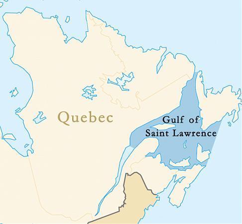
Gulf of Saint Lawrence (French: golfe du Saint-Laurent), the world's largest estuary, is the outlet of North America's Great Lakes via the Saint Lawrence River into the Atlantic Ocean.
The gulf is bounded on the north by the Labrador Peninsula, to the east by Newfoundland, to the south by the Nova Scotia peninsula and Cape Breton Island, and to the west by the Gaspé and New Brunswick. It contains Anticosti Island, Prince Edward Island, and the Magdalen Islands.
The gulf is bounded on the north by the Labrador Peninsula, to the east by Newfoundland, to the south by the Nova Scotia peninsula and Cape Breton Island, and to the west by the Gaspé and New Brunswick. It contains Anticosti Island, Prince Edward Island, and the Magdalen Islands.
Wikipedia article: http://en.wikipedia.org/wiki/Gulf_of_Saint_Lawrence
Nearby cities:
Coordinates: 48°10'35"N 61°49'41"W
- Malpeque Bay 232 km
- St. Georges Bay (Gulf of St. Lawrence) 238 km
- Sydney Harbour 242 km
- Chedabucto Bay 296 km
- Cobequid Bay 348 km
- St. Margarets Bay 424 km
- Mahone Bay 444 km
- Bay of Fundy 460 km
- Trinity Bay 600 km
- Bonavista Bay 613 km
- Brion Island 51 km
- Îles de la Madeleine / Rocher aux Oiseaux (Bird Rocks) lighthouse 63 km
- Aéroport des Îles-de-la-Madeleine 84 km
- St. Paul Island 166 km
- Great Codroy 194 km
- Cape St. George 194 km
- Big Pond 197 km
- Red Island 197 km
- Throve Point Beach 207 km
- Little Codroy Pond 208 km