Kunlun Mountains
China /
Xinjiang /
Hetian /
World
/ China
/ Xinjiang
/ Hetian
World / People's Republic of China / Xinjiang Uygur / Khotan
mountain, Qinghai-Tibet Plateau
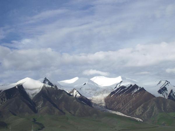
The Kunlun Mountains, known as the "Spine of Asia", tower north of the Qinghai-Tibet Plateau 6,000 meters above sea level, starting from the Pamirs Plateau in the west and extending 2,500 kilometers eastward along the boundary of Xinjiang and Tibet. Viewed from a distance, the snow-covered peaks of the Kunlun Mountains crisscrossed by glaciers look like a huge silvery dragon wreathed in clouds. In spring, when the ice and snow begin to melt on such imposing peaks as Muztag (7,723 meters), Muztagata (7,546 meters) and Kongur (7,719 meters) streams of melt-water flow over the dry land of northwest China and into the Yangtze River and Huanghe river.
The altitude of the highest peak reaches 6,860 meters. The mountains inside Qinghai all belong to the Kunlun Mountain Range, which used to be respected as the origin of all mountains or the mountain of dragon in ancient times. Many fairy tales have something to do with Kunlun Mountain, such as Chang'e (the goddess of the moon), Xi You Ji (Pilgrim to the West), and Bai She Zhuan (Legend of the White Snake). The Kunlun mountain pass is 160 kilometers to the south of Golmud, and the altitude rises from 2,800 meters to 4,700 meters abruptly and the temperature and air pressure drop accordingly. Kunlun is not only famous for its grandeur but also the colour jade it produces, and the jade is called Kunlun Jade.
The Kunlun range as it runs east splits into three branches: the Altun range, which becomes the Qilian Mountains; the Qiangtag range; and the Hohxil range, which becomes the Bayanhar range. The Xinjiang-Tibet Highway crosses the Western part of the Kunlun Mountain Area. The Kunlun range is also the southern boundary of the Tarim Basin, while the Tian Shan mountains are the northern boundary.
Wikipedia article: http://en.wikipedia.org/wiki/Kunlun_Mountains
Nearby cities:
Coordinates: 36°9'2"N 83°59'35"E
- Volcano 131 km
- Keliya (Keriya volcanic field) 177 km
- Adamupaixis volcanic area 212 km
- Baimaoshan 234 km
- Ulugh Muztagh Range (highest point 6,973 m/22,877 feet) 282 km
- Bamaoqiongzong volcanic field 303 km
- Volcanic cone 482 km
- Volcano 532 km
- Miran 550 km
- Mazartag 576 km
- Volcanic field 49 km
- Volcano 130 km
- Heishi Beihu 132 km
- Heishibeihu volcanic field 140 km
- Pelrap Tso 147 km
- Adamupaixis volcanic area 209 km
- Dulihri Tso 248 km
- Pangtag Tso 257 km
- Memar Tso 264 km
- Seldang Tso 272 km
Comments