Former D 2 1 ADA Nike Hercules missile IFC Area
Germany /
Rheinland-Pfalz /
Seibersbach /
World
/ Germany
/ Rheinland-Pfalz
/ Seibersbach
Världen / Deutschland / / Koblenz
Militär, Cold War 1947-1991 (en), nikemissile (en), unsichtbar, geschlossen, stillgelegt, missile silo (en)
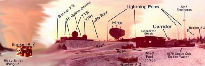
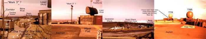
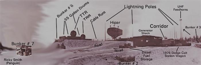
The Nike Hercules was a guided missile controlled from a groundstation. The guidance and control area (Integrated Fire Control, IFC) was located at a distance (about 1 mile) from the area from where the missile was launched (Launching Area, LA). The IFC had a low power acquisition radar (LOPAR) to detect (enemy) aircraft. After detecting and identifying a hostile aircraft with the aid of a Identification friend or foe system, this aircraft was followed or tracked in elevation, azimuth and range by a Target Tracking Radar (TTR). An analog (later digital) computer computed continually a point in the sky where the missile and target should meet (intercept point) after a potential launch of the missile. After the missile was actual launched by the Battery Control Officer (BCO) a Missile Tracking Radar (MTR) tracked the missile and the computer constantly updated the intercept point even if the hostile aircraft performed evasive actions. Steering corrections were sent to the missile by the MTR. When the missile neared the intercept point a command signal was sent to the missile to explode. To measure the range to the target under jamming conditions the IFC was also equipped with a Target Ranging Radar (TRR). Some IFC’s were equipped with a high power acquisition radar (HIPAR) to augment the initial detecting range of hostile aircraft. For command and control the sites were linked with a digitally communication system (initial the AN/MSQ-18 system).
Foto von 1977
Photo by: www.d21dichtelbach.com/nikeherculesmissile.htm
Foto von 1977
Photo by: www.d21dichtelbach.com/nikeherculesmissile.htm
Nearby cities:
Koordinaten: 49°59'40"N 7°43'45"E
- Ehemal. Bundeswehrdepot Rheinböllen 4.8 km
- Ehemaliges Bundeswehr Teildepot Munition Lorch-Ransel 12 km
- Ehemaliger Fliegerhorst Pferdsfeld 18 km
- NLP Kreuz Bingen - Gau-Bickelheim 21 km
- ehemaliges Materiallager 36 km
- Lucius D. Clay Kaserne 42 km
- Anderson Barracks, Dexheim 42 km
- Fliegerhorst Büchel 54 km
- ehemaliger Truppenübungsplatz Daaden 82 km
- Ausweichflugplatz Autobahn Gelsdorf 82 km
- Kandrich (639 m) 0.2 km
- Autobahnanschlußstelle (45) Rheinnöllen 3.1 km
- Autohof Rheinböllen 3.2 km
- Manubach 3.5 km
- Hochsteinchen (648 m) 3.7 km
- Oberdiebach 4 km
- Hochwildschutzpark Hunsrück 6.2 km
- Bacharach 6.2 km
- Kisselbach 11 km
- Oberrheinische Tiefebene. 133 km