Doğubayazıt
Turkey /
Agri /
Dogubeyazit /
World
/ Turkey
/ Agri
/ Dogubeyazit
World / Turkey / Agri
town, district center
• Belediye / Municipality:
www.dogubayazit.bel.tr
• Kaymakamlık / District-Governorate:
www.dogubayazit.gov.tr
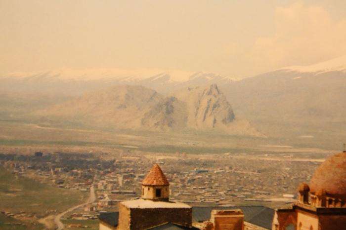
Doğubayazıt (Armenian: Դարոյնք, Դարենից (Daroynk, Darenits') Kurdish: Bazîd) is a kurdish city and district of Ağrı Province of Turkey, and is Turkey's most eastern district, bordering Iran. Its elevation is 1625m and its area is 2,383 km².
The city has a poulation of 74,316 people and is inhabited by Kurds.
Before the Armenian genocide this was an old and prominent Armenian town and was referred to by its Armenian name, Daroynk. The.area has had a rich history with monuments dating back to the time of the Kingdom of Urartu (over 2700 years ago), The castle of Daroynk was built and rebuilt many times throughout this history, although it is now named after the Turkish warlord Celayırlı Şehzade Bayazıt Han who ordered one of the rebuildings (in 1374). Ultimately, the town was renamed Beyazit itself in the 16th century.
The widely dispersed village of Bayazit, originally an Armenian settlement, was populated by Kurds in 1930, when the Turkish army destroyed it. A new town was built in the plain below the old site in the 1930s (hence the new name "Doğubeyazıt" which literally means "East Beyazıt").
www.dogubayazit.bel.tr
• Kaymakamlık / District-Governorate:
www.dogubayazit.gov.tr
Doğubayazıt (Armenian: Դարոյնք, Դարենից (Daroynk, Darenits') Kurdish: Bazîd) is a kurdish city and district of Ağrı Province of Turkey, and is Turkey's most eastern district, bordering Iran. Its elevation is 1625m and its area is 2,383 km².
The city has a poulation of 74,316 people and is inhabited by Kurds.
Before the Armenian genocide this was an old and prominent Armenian town and was referred to by its Armenian name, Daroynk. The.area has had a rich history with monuments dating back to the time of the Kingdom of Urartu (over 2700 years ago), The castle of Daroynk was built and rebuilt many times throughout this history, although it is now named after the Turkish warlord Celayırlı Şehzade Bayazıt Han who ordered one of the rebuildings (in 1374). Ultimately, the town was renamed Beyazit itself in the 16th century.
The widely dispersed village of Bayazit, originally an Armenian settlement, was populated by Kurds in 1930, when the Turkish army destroyed it. A new town was built in the plain below the old site in the 1930s (hence the new name "Doğubeyazıt" which literally means "East Beyazıt").
Wikipedia article: http://en.wikipedia.org/wiki/Doğubeyazıt
Nearby cities:
Coordinates: 39°33'11"N 44°4'42"E
This article is protected.
- 1st Mechanized Infantry Brigade 2.3 km
- Sağdıç 3.3 km
- Zen Vadisi 9 km
- Doğubayazıt District 11 km
- Tendürek Mountain 28 km
- Iğdır Province 37 km
- Çaldıran District 47 km
- Ağrı Province 60 km
- Aras (Haykakan Par) Mountains 104 km
- Van Province 119 km