Makum Hindi School (Makum town)
India /
Assam /
Makum /
Makum town /
National Highway No. 37 (Goalpara-Saikhoa Ghat)
World
/ India
/ Assam
/ Makum
school
Add category
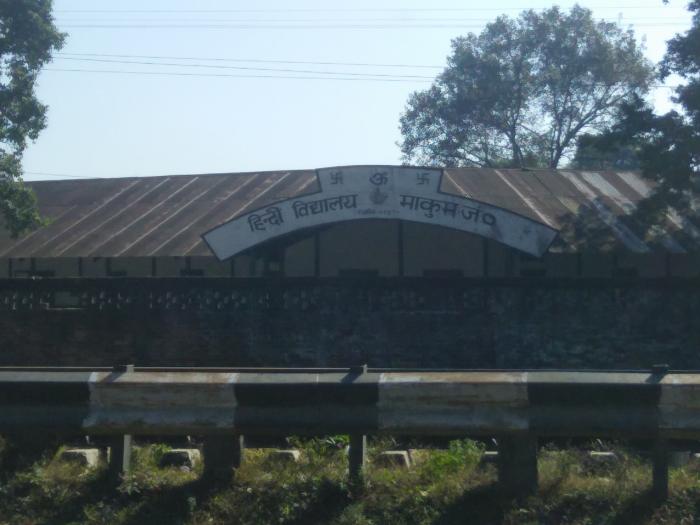
This school was established by the Chinese people of Makum, who were brought here by the British Tea Planters to work in the tea gardens in and around Makum. Name of the town itself derived from the South Chinese word "Ma-Kung", which literally means the "Meet Point". The tea garden labours of nearby estates used to come here on the salary day, to meet their near and dear ones. Makum developed as the largest settlement of Peoples from Chinese origin. They constructed this building on their own and established a school of Chinese language for their children. But, during Indo-China war in 1962, these people were marked as "enemy" and were tortured by local people as well as administration. Some of them were sent to a camp at Rajasthan. Properties of the Chinese people were looted and captured. Since then, this school was left abandoned. Later on, a Hindi school was started in the same building. The building remained same without any major change.
Nearby cities:
Coordinates: 27°29'18"N 95°26'38"E
- Holy Brook School 7.8 km
- Kendriya Vidyalaya, Tinsukia 8.5 km
- vivekananada Kendra Vidyalaya 13 km
- Kendriya Vidyalaya, Duliajan 18 km
- Jawahar Navodaya Vidyalaya, Tinsukia 20 km
- Khathalguri High School 24 km
- KV Campus, Chabua 32 km
- KVele_para (Kendriya Vidyalaya Sangathan) 35 km
- St. Xavier's School 51 km
- Jawahar Navodaya Vidyalaya, Dibrugarh 58 km
- Haveda Tea Estate 1.8 km
- Oil India Terminal 2 km
- OCS, Makum 2.8 km
- 220 kV Grid Sub-Station, Tinsukia 6.5 km
- SBI Colony 7.5 km
- Na Pukhuri ন পুখুৰী 7.9 km
- Bherjan Reserve Forest 8.3 km
- Railway Colony 8.6 km
- St. Lukes Full Campus 8.6 km
- Gela Pukhuri Tea Estate 12 km