James Dean's fatal car accident (actual site)
USA /
California /
Shandon /
World
/ USA
/ California
/ Shandon
World / United States / California
historical layer / disappeared object
Add category

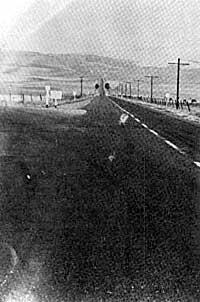

You can see remnants of the OLD Highway 41 and 46.
These two old roads seen here are the real alignment in 1955.
OLD Hiway 46 is interrupted here by the New 41 but you can see the old road to the left of the intersection running parallel and just above the new road.
______________________
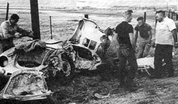
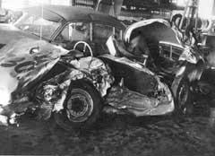
On September 30, 1955, James Dean was driving, traveling with mechanic Rolf Wütherich, westbound on U.S. Highway 466 (later California State Route 46). in a 1955 Porsche 550 Spyder; Donald Turnupseed was traveling east in a 1950 Ford and turned left into Dean's path.
Dean's passenger Rolf Wütherich would later die in another road accident in Germany in 1981.
Donald Turnupseed from Tulare, California, died at age 63 of lung cancer on Thursday, July 13, 1995.
These two old roads seen here are the real alignment in 1955.
OLD Hiway 46 is interrupted here by the New 41 but you can see the old road to the left of the intersection running parallel and just above the new road.
______________________
On September 30, 1955, James Dean was driving, traveling with mechanic Rolf Wütherich, westbound on U.S. Highway 466 (later California State Route 46). in a 1955 Porsche 550 Spyder; Donald Turnupseed was traveling east in a 1950 Ford and turned left into Dean's path.
Dean's passenger Rolf Wütherich would later die in another road accident in Germany in 1981.
Donald Turnupseed from Tulare, California, died at age 63 of lung cancer on Thursday, July 13, 1995.
Wikipedia article: http://en.wikipedia.org/wiki/James_Dean
Nearby cities:
Coordinates: 35°44'3"N 120°17'8"W
- Huron Auxiliary Field (site) 58 km
- Union Oil Tank Farm (site) 64 km
- Historical "Spillway Park" 84 km
- Original Hancock Field (site) 89 km
- Rancho Cañada de Salsipuedes 122 km
- North American Rockwell Corporation Microwave Test Center (site) 137 km
- Submerged Stretch Of Old California Highway 99 180 km
- Circle B Scout ranch. 50's-70's 195 km
- Newhall Intermediate Airfield (site) 217 km
- Trem Carr's Placeritos Movie Ranch 223 km
- Shandon Hills Vineyard 14 km
- Red Cedar Vineyards 18 km
- Shimmin Canyon Vineyard 20 km
- Fetzer Five Rivers Vineyard 24 km
- Cellar 360 Vineyard 26 km
- French Camp Vineyards 27 km
- Keyes Canyon Ranch Vineyards (Estancia) 27 km
- San Andreas Fault Zone (approx) 33 km
- Gallo Vineyards Sunnybrook Ranch 34 km
- Los Padres National Forest 101 km
Comments