Milligan Cemetery
USA /
California /
Needles /
World
/ USA
/ California
/ Needles
World / United States / California
cemetery, place with historical importance

Milligan Cemetery
Milligan, San Bernardino County, California
Lat: 34° 16' 41"N, Lon: 115° 09' 51"W
T2N R17E Sec 11
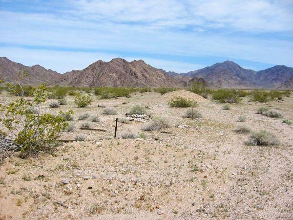
The Milligan Cemetery is at the site of the former railroad siding at Milligan. To reach Milligan take the Cadiz Road turnoff from National Old Trails Highway, 12.5 miles east of Amboy. Turn south and follow the paved road 4.4 miles until it crosses the railroad track. The pavement ends on the south side of the track.
The road to Milligan is the wide dirt road straight ahead. Follow the road 25.9 miles, parallel to the railroad tracks until you come to the railroad siding at Milligan marked with a sign "Miligan" at the south end of the Old Woman Mountains. The site of the former railroad settlement is marked by several salt cedar trees with concrete cisterns built around the base by the former residents. The cemetery is on the north side of the tracks about 200 feet northeast of a now unused ramp.
Milligan is completely deserted and only the foundations remain of the section houses that were once there. The settlement served as a watering stop for the railroad and as a supply point for some of the mines in the area that were in operation in the early 1900's.
There are about 11 graves at Milligan. When first visited this cemetery on Feb 08, 2002 based on a description from Paul Limon, a former resident of Chubbuck who commented that his baby brother died as an infant and was buried at Milligan. Three of the graves had wooden sticks or crosses with no information. The other graves were marked with stones.
Paul inscribed his brother's name on the baby's grave. There is no indication of names on any of the other graves.
Milligan, San Bernardino County, California
Lat: 34° 16' 41"N, Lon: 115° 09' 51"W
T2N R17E Sec 11
The Milligan Cemetery is at the site of the former railroad siding at Milligan. To reach Milligan take the Cadiz Road turnoff from National Old Trails Highway, 12.5 miles east of Amboy. Turn south and follow the paved road 4.4 miles until it crosses the railroad track. The pavement ends on the south side of the track.
The road to Milligan is the wide dirt road straight ahead. Follow the road 25.9 miles, parallel to the railroad tracks until you come to the railroad siding at Milligan marked with a sign "Miligan" at the south end of the Old Woman Mountains. The site of the former railroad settlement is marked by several salt cedar trees with concrete cisterns built around the base by the former residents. The cemetery is on the north side of the tracks about 200 feet northeast of a now unused ramp.
Milligan is completely deserted and only the foundations remain of the section houses that were once there. The settlement served as a watering stop for the railroad and as a supply point for some of the mines in the area that were in operation in the early 1900's.
There are about 11 graves at Milligan. When first visited this cemetery on Feb 08, 2002 based on a description from Paul Limon, a former resident of Chubbuck who commented that his baby brother died as an infant and was buried at Milligan. Three of the graves had wooden sticks or crosses with no information. The other graves were marked with stones.
Paul inscribed his brother's name on the baby's grave. There is no indication of names on any of the other graves.
Nearby cities:
Coordinates: 34°16'39"N 115°9'57"W
- Montecito Memorial Park 197 km
- Riverside National Cemetery 200 km
- Eternal Hills Cemetery 234 km
- El Camino Memorial Park - Sorrento Valley 242 km
- Miramar National Cemetery 244 km
- Forest Lawn Cemetery - Covina 248 km
- Rose Hills Memorial Park 267 km
- Rose Hills Memorial Park 268 km
- Forest Lawn Memorial Park 271 km
- Resurrection Cemetery 272 km
- Danby Lake 9 km
- Old Woman Mountains 18 km
- Camp Iron Mountain (site) 20 km
- Camp Granite (site) 24 km
- Vidal Valley 36 km
- Coxcomb Mountains 41 km
- Palen Pass: Desert Training Center Maneuvers Area 41 km
- Camp Rice (site) 43 km
- Palen Mountains 54 km
- Riverside Mountains Wilderness Area 62 km