Site of former "Hochwald" (Himmler's Fieldheadquarter)
Poland /
Warminsko-Mazurskie /
Wegorzewo /
World
/ Poland
/ Warminsko-Mazurskie
/ Wegorzewo
World / Poland / Warmian-Masurian
monument, ruins, bunker, interesting place, historic landmark, historical layer / disappeared object
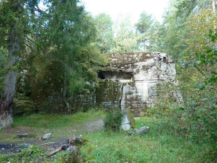

Near the village of Grossgarten (in 1938 the Angerburg Region transfered old slawic names into more "german like" names, e.g. Possessern into Großgarten, now Polish Pozezdrze), which is some 20 km east of Hitlers "Wolfsschanze", the remains of "Feldkommandostelle Hochwald" (or "Schwarzschanze"="Blacklair") can be found east of the old Angerburg - Lötzen (in Polish Węgorzewo-Gizycko) road.
It served as East-Prussian Field HQ of SS- and Gestapo chief Heinrich Himmler.
It was constructed in a forest in 1941 and consisted of a number of large bunkers and several other buildings protected by mine-fields and barbed wire fences.
On January 14, 1945 the bunkers were demolished by German Pionieres.
Current state:
Although somewhat demolished the best preserved bunker is Himmler's.
You can still visit this facility: Parking is about 1 km north of the town Pozezdrze on the east side along the road Węgorzewo-Gizycko.
www.pomazurach.bezsternika.pl/html/Powiat%20Wegorzewo%2...
www.pomazurach.bezsternika.pl/html/Galerie/Wegorzewo%20...
Nearby cities:
Coordinates: 54°9'9"N 21°51'6"E
- Boyen Fortress 15 km
- Wolf's Lair, FHQ Wolfsschanze 26 km
- Former German cemetery 26 km
- Wilamowo 30 km
- Ancient Settlement 36 km
- Ancient Settlement 40 km
- Straduny 41 km
- Electrical Substation 51 km
- Ełk 220 kV Substation 52 km
- Electrical sub-station 61 km
- Lake Pozezdrze 2.8 km
- Lake Wilkus 4.8 km
- Krzywa Kuta 7.3 km
- Lake Gołdopiwo 7.6 km
- Kruklin Lake 12 km
- Niegocin Lake 18 km
- Wydmińskie 19 km
- Wojnowo 22 km
- Gawlik 22 km
- Szóstak 28 km
Comments