Ondiri Swamp
Kenya /
Central /
Kikuyu /
World
/ Kenya
/ Central
/ Kikuyu
Kenya / World / Central / Kiambu / Kikuyu / Kikuyu
a very famous swamp that is a breather of L. Naivasha2.0 Ũndirí Wetland at a Glance
2.1 Ũndirí wetland is located within close proximity to Kikuyu town. It is an important wetland since it forms the headwaters of Nairobi River within the Athi drainage basin. The area is a unique wetland with macrophytes growing on a floating peat. Peat occurrence in Kenya is scattered and limited to mountainous areas with most valley bottom wetland having been drained for farming and settlements. In spite of this uniqueness, the wetland is characterized by poor or scanty information on its ecology, utilization and threats as is the case with most small wetland ecosystems in the country.
2.2 Stakeholders within Ũndirí wetland include local farmers, institutions like schools, hospitals, government departments and civil society organizations. Activities in Ũndirí wetland include water abstraction for both irrigation and domestic use and Macrophyates are harvested, mainly as forage for livestock both for commercial and domestic use. Due to its close proximity to Kikuyu town and Nairobi city, it is an important source of horticultural products. Local people also use it intermittently as a recreation site. The peat within Ũndirí wetland, has also been used previously as a carrier material for rhizobium inoculation bacteria.
2.3 Ecosystem destruction in Ũndirí wetland dates back to the colonial era, which was marked by extensive deforestation. Currently the ecosystem is highly threatened by various activities within both the wetlands and riparian land. This includes dumping of solid waste and uncontrolled water abstraction. There are several water pumps around the wetland, which are not metered meaning that it is impossible to gauge the level of water abstraction. In addition, there are fears that the water in the wetland has been reducing. But again the out flowing river does not have a gauging station. Kikuyu town also lacks a sewerage system, which increases the likelihood of pollutants seepage from septic tanks. Previous conservation initiatives mainly fencing and tree planting by forest departments in the 1990’s collapsed due to lack of community ownership of the process and enforcement.
2.4 Preliminary research, reveals that very little has been documented on Ũndirí and that may explain why despite the lifeline it gives to many households, it has not been listed among wetlands of national importance or protected as a Ramsar Site. Ũndirí wetland is one of the few perennial highland bogs. It is a resource that draws interest in various quarters, which include government departments, local authority, farmers and private developers. The fact that it is not protected and its other resources controlled, multiplicity of stakeholders present a situation where each individual seeks to maximize their benefits; a pure case of the tragedy of the commons. This complicates the position of management and conservation agencies.
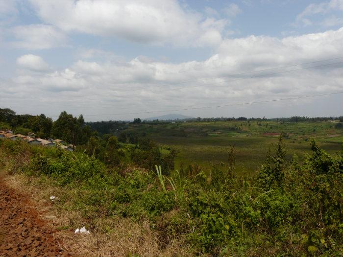
2.5 The Ũndirí wetland is oval in shape and local legend has it that it used to be an open lake in the early part of the last century and indeed the name itself is Gikuyu corruption of old lake (Ũndirí). However as deforestation and subsequent erosion accelerated, the lake came to be covered with floating reeds on peat such that now it has an extensive reed mat that covers more than 95 percent of the wetland to form a quacking bog, the only one in the country. A quacking bog is made up of a layer of vegetation floating over water. You can walk on the vegetation, but if you jump up and down the whole bog quakes (Macharia and Thenya, 2007).
2.6 The wetland covers an area of approximately 30 hectares with a perimeter of slightly over 3km. Hydrologists say the water sits on a valley of about 10kms. The Ũndirí wetland lies at 2000m above sea level. The area gently slopes eastwards to around 1600m above sea level with the wetland sitting approximately 10m below the general topography of the area. To the north of the wetland, a large area on which sits Kikuyu town, slopes southwards towards the wetland.
2.7 The wetland’s vegetation comprises of reeds and water grass. This vegetation grows continuously and when it wilts, it does not decompose completely. Instead, it accumulates to form a thick layer of peat (up to 50cm thick) that floats on Ũndirí’s water (Kinyanjui, 2002).
2.8 The wetland provides crucial breeding sites for insects, crustaceans and amphibians. These provide adequate food for birds during breeding and migration. An earlier study also noted the huge presence of storks, egrets, ibises, hamerkops, kingfishers, cranes, plovers and painted snipes feeding on frogs, tadpoles and other aquatic fauna during the dry seasons. The marabou stork is also a rare visitor to the wetland. Jackson’s widows have been spotted breeding in the tall grass in the wetland (Ng’weno 1992). Ng’weno 1992 also noted that the tall grass provided security for small carnivores such as mongoose and wildcats. However, that was before the harvesting of the grass became intensive and frequent.
2.10 The wetland gets its water through the northern end and discharges southwards into Nyongara River. The wetland is fed by three small streams and several small seasonal springs located at the edges of the wetland and runoff the neighboring land. It is most likely that it has an underground source of water which explains why it is perennial (Macharia and Thenya, 2007). In addition, it is also fed by rainfall and overland flow from the surrounding areas. During the rainy season, most floodwaters in this area drain into the wetland. Baraniki and lower Thogoto areas are characterized by valleys and rocks and the latter is evident from the many quarries that dot the two areas. It is no wonder that several small streams and springs sprout from the joints and faults in the area.
2.11 The main direction of outflow of the wetland is to the south and east where several small streams join downstream to form larger streams that make the headwaters of Nairobi River. The water body is linked to Kikuyu Springs, which lies to its east through a subterranean passage. The spring is a major source of Nairobi’s water throughout the year and it is under a 24-hour guard from the Administration Police. Together with other streams that emanate from Ũndirí wetland and elsewhere it forms a significant catchment for Nairobi River.
2.12 The south of Ũndirí wetland forms the headwaters of Athi River. After passing underground through Thogoto forest it resurfaces at Karinde near Karen Estate, where locals refer to it as Gitwe Kia Mbagathi (headwaters of Mbagathi). To the southeast the water from Ũndirí forms the Nyongara River, which passes through highly populated areas such as Thogoto, Dagoretti Market, Waithaka, Uthiru and Kawangware, finally joining the Nairobi River at Waithaka. The areas are mainly inhabited by low-income people and if the Wetland is to be well managed, the residents of these areas would greatly benefit from the water.
2.13 The current land use around the wetland is a mix between residential plots, small gardens, some large farms and exotic vegetation. The area has a high population density with current figures putting it at about 500 persons per km2. As such, land is very important. The land is divided into small portions on which permanent or semi permanent residential structures are erected. This is attributed to the fact that residential houses have a higher return compared to small-scale agriculture.
2.14 Ũndirí is a unique and an important wetland. As noted earlier, Ũndirí is Kenya’s only quaking bog and the second deepest wetland in Africa after Doula in Cameroon. But despite the size and benefits of Ũndirí wetland to this country it has received only scant attention from researchers, writers, natural resource environmental management and the large conservation driven organizations. Equally the governments both central and local have done little to conserve the wetland for posterity. Media mention of this wetland is also scattered and limited in scope.
2.15 Preliminary observations reveal that there has been an unwise use of the resource, which has brought problems for the wetland. For instance the intensive agricultural activities settlements and urbanization has led to ecosystem loses and fragmentation hence the disappearance of the plants, birds and other forms of life associated with wetlands. The degradation has also led to increased soil erosion, which has affected the biological process of aquatic organisms. The use of fertilizers and other types of inorganic manure in the catchment has resulted in excessive growth of algae. Excessive organic matter production by algae creates conditions that kill the various forms of life resident in the wetland.
2.16 The Ũndirí hosts a sizeable amount of reeds, which have immense value in the area where they are sustainably harvested. They provide aesthetically pleasing roofs, just like the conventional tile or iron sheet roofs. The reeds can also serve as raw materials for baskets and
2.1 Ũndirí wetland is located within close proximity to Kikuyu town. It is an important wetland since it forms the headwaters of Nairobi River within the Athi drainage basin. The area is a unique wetland with macrophytes growing on a floating peat. Peat occurrence in Kenya is scattered and limited to mountainous areas with most valley bottom wetland having been drained for farming and settlements. In spite of this uniqueness, the wetland is characterized by poor or scanty information on its ecology, utilization and threats as is the case with most small wetland ecosystems in the country.
2.2 Stakeholders within Ũndirí wetland include local farmers, institutions like schools, hospitals, government departments and civil society organizations. Activities in Ũndirí wetland include water abstraction for both irrigation and domestic use and Macrophyates are harvested, mainly as forage for livestock both for commercial and domestic use. Due to its close proximity to Kikuyu town and Nairobi city, it is an important source of horticultural products. Local people also use it intermittently as a recreation site. The peat within Ũndirí wetland, has also been used previously as a carrier material for rhizobium inoculation bacteria.
2.3 Ecosystem destruction in Ũndirí wetland dates back to the colonial era, which was marked by extensive deforestation. Currently the ecosystem is highly threatened by various activities within both the wetlands and riparian land. This includes dumping of solid waste and uncontrolled water abstraction. There are several water pumps around the wetland, which are not metered meaning that it is impossible to gauge the level of water abstraction. In addition, there are fears that the water in the wetland has been reducing. But again the out flowing river does not have a gauging station. Kikuyu town also lacks a sewerage system, which increases the likelihood of pollutants seepage from septic tanks. Previous conservation initiatives mainly fencing and tree planting by forest departments in the 1990’s collapsed due to lack of community ownership of the process and enforcement.
2.4 Preliminary research, reveals that very little has been documented on Ũndirí and that may explain why despite the lifeline it gives to many households, it has not been listed among wetlands of national importance or protected as a Ramsar Site. Ũndirí wetland is one of the few perennial highland bogs. It is a resource that draws interest in various quarters, which include government departments, local authority, farmers and private developers. The fact that it is not protected and its other resources controlled, multiplicity of stakeholders present a situation where each individual seeks to maximize their benefits; a pure case of the tragedy of the commons. This complicates the position of management and conservation agencies.
2.5 The Ũndirí wetland is oval in shape and local legend has it that it used to be an open lake in the early part of the last century and indeed the name itself is Gikuyu corruption of old lake (Ũndirí). However as deforestation and subsequent erosion accelerated, the lake came to be covered with floating reeds on peat such that now it has an extensive reed mat that covers more than 95 percent of the wetland to form a quacking bog, the only one in the country. A quacking bog is made up of a layer of vegetation floating over water. You can walk on the vegetation, but if you jump up and down the whole bog quakes (Macharia and Thenya, 2007).
2.6 The wetland covers an area of approximately 30 hectares with a perimeter of slightly over 3km. Hydrologists say the water sits on a valley of about 10kms. The Ũndirí wetland lies at 2000m above sea level. The area gently slopes eastwards to around 1600m above sea level with the wetland sitting approximately 10m below the general topography of the area. To the north of the wetland, a large area on which sits Kikuyu town, slopes southwards towards the wetland.
2.7 The wetland’s vegetation comprises of reeds and water grass. This vegetation grows continuously and when it wilts, it does not decompose completely. Instead, it accumulates to form a thick layer of peat (up to 50cm thick) that floats on Ũndirí’s water (Kinyanjui, 2002).
2.8 The wetland provides crucial breeding sites for insects, crustaceans and amphibians. These provide adequate food for birds during breeding and migration. An earlier study also noted the huge presence of storks, egrets, ibises, hamerkops, kingfishers, cranes, plovers and painted snipes feeding on frogs, tadpoles and other aquatic fauna during the dry seasons. The marabou stork is also a rare visitor to the wetland. Jackson’s widows have been spotted breeding in the tall grass in the wetland (Ng’weno 1992). Ng’weno 1992 also noted that the tall grass provided security for small carnivores such as mongoose and wildcats. However, that was before the harvesting of the grass became intensive and frequent.
2.10 The wetland gets its water through the northern end and discharges southwards into Nyongara River. The wetland is fed by three small streams and several small seasonal springs located at the edges of the wetland and runoff the neighboring land. It is most likely that it has an underground source of water which explains why it is perennial (Macharia and Thenya, 2007). In addition, it is also fed by rainfall and overland flow from the surrounding areas. During the rainy season, most floodwaters in this area drain into the wetland. Baraniki and lower Thogoto areas are characterized by valleys and rocks and the latter is evident from the many quarries that dot the two areas. It is no wonder that several small streams and springs sprout from the joints and faults in the area.
2.11 The main direction of outflow of the wetland is to the south and east where several small streams join downstream to form larger streams that make the headwaters of Nairobi River. The water body is linked to Kikuyu Springs, which lies to its east through a subterranean passage. The spring is a major source of Nairobi’s water throughout the year and it is under a 24-hour guard from the Administration Police. Together with other streams that emanate from Ũndirí wetland and elsewhere it forms a significant catchment for Nairobi River.
2.12 The south of Ũndirí wetland forms the headwaters of Athi River. After passing underground through Thogoto forest it resurfaces at Karinde near Karen Estate, where locals refer to it as Gitwe Kia Mbagathi (headwaters of Mbagathi). To the southeast the water from Ũndirí forms the Nyongara River, which passes through highly populated areas such as Thogoto, Dagoretti Market, Waithaka, Uthiru and Kawangware, finally joining the Nairobi River at Waithaka. The areas are mainly inhabited by low-income people and if the Wetland is to be well managed, the residents of these areas would greatly benefit from the water.
2.13 The current land use around the wetland is a mix between residential plots, small gardens, some large farms and exotic vegetation. The area has a high population density with current figures putting it at about 500 persons per km2. As such, land is very important. The land is divided into small portions on which permanent or semi permanent residential structures are erected. This is attributed to the fact that residential houses have a higher return compared to small-scale agriculture.
2.14 Ũndirí is a unique and an important wetland. As noted earlier, Ũndirí is Kenya’s only quaking bog and the second deepest wetland in Africa after Doula in Cameroon. But despite the size and benefits of Ũndirí wetland to this country it has received only scant attention from researchers, writers, natural resource environmental management and the large conservation driven organizations. Equally the governments both central and local have done little to conserve the wetland for posterity. Media mention of this wetland is also scattered and limited in scope.
2.15 Preliminary observations reveal that there has been an unwise use of the resource, which has brought problems for the wetland. For instance the intensive agricultural activities settlements and urbanization has led to ecosystem loses and fragmentation hence the disappearance of the plants, birds and other forms of life associated with wetlands. The degradation has also led to increased soil erosion, which has affected the biological process of aquatic organisms. The use of fertilizers and other types of inorganic manure in the catchment has resulted in excessive growth of algae. Excessive organic matter production by algae creates conditions that kill the various forms of life resident in the wetland.
2.16 The Ũndirí hosts a sizeable amount of reeds, which have immense value in the area where they are sustainably harvested. They provide aesthetically pleasing roofs, just like the conventional tile or iron sheet roofs. The reeds can also serve as raw materials for baskets and
Nearby cities:
Coordinates: 1°14'57"S 36°39'31"E
- Kidfarmaco,Kikuyu 0.7 km
- magana farm 1.4 km
- University of Nairobi Farms 5.2 km
- Kabiria 7.6 km
- Lenana School 8.9 km
- Ng'ong' Township 10 km
- Institute of Primate Research 12 km
- Ngong Hills Wind Farm 14 km
- Nkoroi 15 km
- Seventh Day Adventist (S.D.A.) Headquarters for Eastern Africa 18 km
- Alliance High School 1.3 km
- Alliance Girls High School 1.9 km
- Mutego 2.6 km
- Africa International University 7 km
- International Livestock Research Institute (ILRI) 7.7 km
- Kabete Approved Juvenile School 8 km
- University of Nairobi, Kabete Campus 8.2 km
- Mountain View Estate 9 km
- Ngando Area, Nairobi. 11 km
- Ngong Forest 13 km
Comments