Wreck of USS Mullinnix (DD-944)
Puerto Rico /
Guayama /
Maunabo /
World
/ Puerto Rico
/ Guayama
/ Maunabo
World / United States Virgin Islands
military, shipwreck, United States Navy

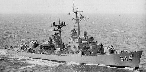


The 11th member of the Forrest Sherman Class of Destroyers, USS Mullinnix commissioned into US Navy service in 1958 and served with the Atlantic Fleet for her entire life, seeing action in the Cuban Missile Crisis as well as Vietnam.
She decommissioned in 1983 and was laid up in the James River Reserve Fleet until 1990 when she was withdrawn and prepared for use as a target ship. USS Mullinnix met her end at this location on August 22, 1992 as a target for air and ship launched missiles.
www.navsource.org/archives/05/944.htm
She decommissioned in 1983 and was laid up in the James River Reserve Fleet until 1990 when she was withdrawn and prepared for use as a target ship. USS Mullinnix met her end at this location on August 22, 1992 as a target for air and ship launched missiles.
www.navsource.org/archives/05/944.htm
Wikipedia article: http://en.wikipedia.org/wiki/USS_Mullinnix_(DD-944)
Nearby cities:
Coordinates: 17°9'42"N 65°41'53"W
- US Navy Range/Roosevelt Roads Naval Station (Former) 117 km
- Camp Santiago Joint Manuever Training Center 120 km
- Roosevelt Roads Naval Station (Closed) 125 km
- Fort Buchanan, US Army 148 km
- Base desactivada. Sabana Seca South Tract 152 km
- Isla de Aves 271 km
- Fuerte Tiuna: Cuarteles y Hospital Militar. 756 km
- Barcelona (Venezuela) (BLA) International Airport 790 km
- Baza Lotnicza im. kpt Manuela Riosa 877 km
- Tiriós Airbase - Brazil 1973 km
- Patillas Maritime Zone 91 km
- Maunabo Maritime Zone 92 km
- Arroyo Maritime Zone 93 km
- Yabucoa Maritime Zone 96 km
- Palmas 97 km
- Guayama Maritime Zone 97 km
- Pitahaya 101 km
- Hovensa Oil Refinery 117 km
- St. Croix, USVI 120 km
- United States Virgin Islands 136 km
Comments