Castanhão Dam (Jaguaribara)
Brazil /
Ceara /
Jaguaribe /
Jaguaribara
World
/ Brazil
/ Ceara
/ Jaguaribe
World / Brazil / Ceará / Jaguaribara
weir
Add category
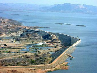

The Dam is a dam Castanhão Brazilian built on the riverbed Jaguaribe in the state of a dam Ceará.Ele is therefore, technically speaking. The dam is located in Jaguaribara but reaches other cities.
The work was begun in 1995 during the Tasso Jereissati, and completed in 2003 by Governor Beni Veras (PSDB), a partnership between the Department of Water Resources of Ceara - SRH-CE and the National Department of Works Against Droughts - DNOCS.
During construction of the dam was necessary to remove the old seat of the municipality of Jaguaribara, which was under águas.Em replace the underwater city, built the city of New Jaguaribara.
The weir consists of Castanhão the geographical limits of at least four municipalities of Ceará: Jaguaribara (New Jaguaribara), High St., and Jaguaretama Jaguaribe, given their large size.
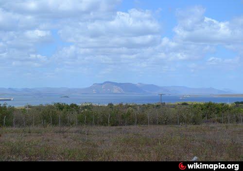
Represents an important control mechanism of drought and seasonal flooding that hit the valley Jaguaribe, as well as growing in importance to the rest of Ceara, while strategic water reserve for the state.
The storage capacity is 6.7 billion m³ Castanhão, which ranks as the largest multi-purpose dam in Latin America. It alone has 37% of all the storage capacity of reservoirs 8000 cearenses.Antes Castanhão of the largest dam was Orós Ceará, in the municipality of the same name, which is also a dam on the Rio Jaguaribe, but which contains little more than half the ability of Castanhão.
The Castanhão is a marvel of modern engineering, complete in this century, but whose designs date back the early 19th century when the first studies to build a work that would ensure water supply to cope with irregular rainfall in semiarid Nordestino.Destaquedeserves special engineer at Stanford University, "" Sir Roderic Crandall, who identified the area known as "Big mouth of the Wedge, where currently this dam, a series of geological markers that indicated that to be the best area for the construction of the dam.
The work was begun in 1995 during the Tasso Jereissati, and completed in 2003 by Governor Beni Veras (PSDB), a partnership between the Department of Water Resources of Ceara - SRH-CE and the National Department of Works Against Droughts - DNOCS.
During construction of the dam was necessary to remove the old seat of the municipality of Jaguaribara, which was under águas.Em replace the underwater city, built the city of New Jaguaribara.
The weir consists of Castanhão the geographical limits of at least four municipalities of Ceará: Jaguaribara (New Jaguaribara), High St., and Jaguaretama Jaguaribe, given their large size.
Represents an important control mechanism of drought and seasonal flooding that hit the valley Jaguaribe, as well as growing in importance to the rest of Ceara, while strategic water reserve for the state.
The storage capacity is 6.7 billion m³ Castanhão, which ranks as the largest multi-purpose dam in Latin America. It alone has 37% of all the storage capacity of reservoirs 8000 cearenses.Antes Castanhão of the largest dam was Orós Ceará, in the municipality of the same name, which is also a dam on the Rio Jaguaribe, but which contains little more than half the ability of Castanhão.
The Castanhão is a marvel of modern engineering, complete in this century, but whose designs date back the early 19th century when the first studies to build a work that would ensure water supply to cope with irregular rainfall in semiarid Nordestino.Destaquedeserves special engineer at Stanford University, "" Sir Roderic Crandall, who identified the area known as "Big mouth of the Wedge, where currently this dam, a series of geological markers that indicated that to be the best area for the construction of the dam.
Nearby cities:
Coordinates: 5°37'22"S 38°34'56"W
- Açude Pau dos Ferros - Rio Grande do Norte - Brasil 72 km
- Açude Castro - Ceará - Brasil 129 km
- Açude Aracoiaba - Ceará - Brasil 143 km
- Açude Pacajus - Ceará - Brasil 163 km
- Açude de Coremas - Paraíba - Brasil 165 km
- Açude Pacoti 178 km
- Açude Gavião - Ceará - Brasil 192 km
- Açude Acaraú-Mirim - Ceará - Brasil 307 km
- Açude Boqueirão de Cabaceiras - Paraíba - Brasil 326 km
- Açude Argemiro de Figueiredo - Paraíba - Brasil 386 km
- Açude Canafístula - Ceará - Brasil 30 km
- Açude Ema 35 km