Back Cove (Portland, Maine)
USA /
Maine /
Portland /
Portland, Maine
World
/ USA
/ Maine
/ Portland
World / United States / Maine
water, cove
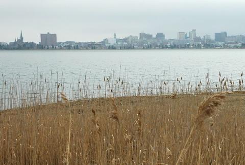
Bordered on the West and North by Baxter Boulevard, named after turn of the [20th] century mayor, who hired Olmstead to design
this "parkway" style park. The cove has shrunk several times, (by filling) since 1837, and in 1960+/- with the construction of the new
Interstate 295. During most low tides it is a tidal flat. The stone dust surfaced trail is approximately 3 3/4 miles long, although the
official markings would have you believe it is 3.5 miles.
From mid-May to mid-September there is a free 5k race around Back Cove every Wednesday evening at 6:00 pm.
(Please note: This is a "cove", people! "Back Bay" is in Boston. Thanks much.)
Wikipedia article: http://en.wikipedia.org/wiki/Back_Cove,_Portland,_Maine
Nearby cities:
Coordinates: 43°40'22"N 70°16'1"W
- Casco Bay (Southern Section) 6.4 km
- Middle Bay 24 km
- Harpswell Sound 25 km
- Maquoit Bay 26 km
- Kennebec Estuary (southern portion) 42 km
- Shepscott River Estuary 49 km
- Hockomock Bay / Montwaeg Bay 51 km
- Damariscotta River Estuary (Southern section) 60 km
- Sheepscot River 62 km
- St. Georges River Estuary 91 km
- Back Cove 1.1 km
- Bayside 1.1 km
- Oakdale 1.2 km
- East End/Munjoy Hill 1.7 km
- Downtown 1.9 km
- West End 2.8 km
- Ferry Village 3.7 km
- Knightville 4.5 km
- Willard 4.5 km
- Scarborough, Maine 13 km