Osorno
| city
Chile /
Los Lagos /
Osorno /
World
/ Chile
/ Los Lagos
/ Osorno
World / Chile / Los Lagos / Osorno
city
Add category


Osorno is a city of nearly 150,000 inhabitants, as of the 2002 census, located in the south of Chile. It is the capital of Osorno Province in the Los Lagos Region. It is 945 km to the south of the capital of the country, Santiago, 110 km north of Puerto Montt (the regional capital) and 260 km west of the Argentine city of San Carlos de Bariloche, which is connected to it by International Route 215 via the Cardenal Antonio Samoré Pass.
The city was originally planned to be founded in 1553, under the Government of Pedro de Valdivia by his companion of conquest, Lieutenant General Don Francisco de Villagra; with the name of Santa Marina de Gaete, on the site of a Huilliche village named Chauracavi. However, the death of Valdivia prevented the realization of this plan when he was about to materialize.
On March 27, 1558, the city is finally founded by the governor, García Hurtado de Mendoza, Marquis of Cañete; with the new name of Villa de San Mateo de Osorno, in honor of his grandfather, Count of Osorno. It was destroyed again by the indigenous Huilliche people in 1602.
On November 22, 1792, Tomás de Figueroa took possession of the ruins. Under the orders of Ambrosio O'Higgins, Osorno was again rebuilt by Juan Mackenna, and declared officially re-populated in 1796. O'Higgins, in turn, was awarded the title of Marquess of Osorno. Around 1850, the government of Chile began inviting German settlers to the colony to promote growth in the region; the settlers found Osorno's climate and geography to be very similar to their own. With their help, Osorno was made the home of the National Cattle ranch of Chile, boosting the regional economy significantly. Present-day Osorno has preserved 19th century architecture and urban layout, represented by six picturesque houses which have been designated national monuments.
Osorno has a long history of rivalry with Valdivia, and in a 2006 referendum, the Osorno Province rejected its proposed incorporation into the new Los Ríos Region, of which Valdivia is now the capital.
The City
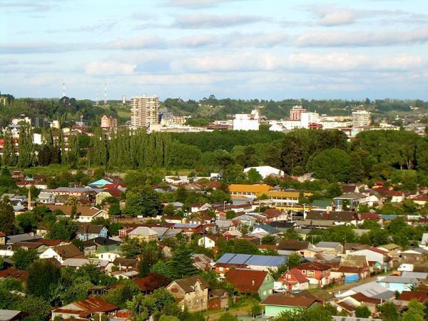
Osorno sits in sight of Volcán Osorno, an active but minor volcano. The city's most prominent geographical feature is the Rahue River that runs North-South through its center. A smaller steam breaks off as well, running East before turning South and giving the city some natural boundaries. Located near the river front on the east side is the city's heart, the Plaza de Armas, a large, one-block park with fountains, benches, and tree-lined avenues. On the park's east side is the Catedral of Saint Matthew, one of the city's major landmarks, notable for its modern architecture. The cathedral serves as mother church of the Catholic Diocese of Osorno. Along the south side is Juan Mackenna Avenue, the city's major City Centre street. Other points of interest are the main campus of the Universidad de Los Lagos and the Osorno Rodeo Stadium. The Estadio Municipal Parque Schott is an outdoor stadium open to the community. Recently, Osorno unveiled plans for a casino, which will be called Plaza Sol de los Lagos and is expected to boost tourism to the region.
Osorno hosts a number of annual festivals. The Milk and Meat Fair showcases the city's agricultural past, while the SAGO-FISUR Cattle Fair hosted by the largest ranch in the area highlights the current state of agricultural activity. Fireworks displays are held every year around the city on September 18th, the Chilean Independence Day, commemorating independence from Spain.
Osorno is also a gateway for many tourist attractions. Puyehue National Park is a major attraction, with pristine lakes, forests, and game preserves. The volcanic area provides natural hot springs, now the site of the Aguas Calientes spa. Puyehue Hot Springs is adjacent to the park.
Los Lagos Region was named for the many lakes in the area, many of which have tourist-friendly yet isolated beaches; closest to Osorno are Puyehue and Rupanco. [2] Antillanca ski resort, less than a hundred kilometers away, is one of the highest-quality resorts in Chile. Ecotourism is also encouraged by the indigenous Huilliche communities, who inhabit the Pacific coastal zone. Much of the funds brought in by tourism is being used to protect native plant and tree species, most notably the Alerce, a threatened cyprus. The thick forests open onto beautiful beaches and bays, such as Maicolpué, Bahía Mansa and Pucatrihue.
The city was originally planned to be founded in 1553, under the Government of Pedro de Valdivia by his companion of conquest, Lieutenant General Don Francisco de Villagra; with the name of Santa Marina de Gaete, on the site of a Huilliche village named Chauracavi. However, the death of Valdivia prevented the realization of this plan when he was about to materialize.
On March 27, 1558, the city is finally founded by the governor, García Hurtado de Mendoza, Marquis of Cañete; with the new name of Villa de San Mateo de Osorno, in honor of his grandfather, Count of Osorno. It was destroyed again by the indigenous Huilliche people in 1602.
On November 22, 1792, Tomás de Figueroa took possession of the ruins. Under the orders of Ambrosio O'Higgins, Osorno was again rebuilt by Juan Mackenna, and declared officially re-populated in 1796. O'Higgins, in turn, was awarded the title of Marquess of Osorno. Around 1850, the government of Chile began inviting German settlers to the colony to promote growth in the region; the settlers found Osorno's climate and geography to be very similar to their own. With their help, Osorno was made the home of the National Cattle ranch of Chile, boosting the regional economy significantly. Present-day Osorno has preserved 19th century architecture and urban layout, represented by six picturesque houses which have been designated national monuments.
Osorno has a long history of rivalry with Valdivia, and in a 2006 referendum, the Osorno Province rejected its proposed incorporation into the new Los Ríos Region, of which Valdivia is now the capital.
The City
Osorno sits in sight of Volcán Osorno, an active but minor volcano. The city's most prominent geographical feature is the Rahue River that runs North-South through its center. A smaller steam breaks off as well, running East before turning South and giving the city some natural boundaries. Located near the river front on the east side is the city's heart, the Plaza de Armas, a large, one-block park with fountains, benches, and tree-lined avenues. On the park's east side is the Catedral of Saint Matthew, one of the city's major landmarks, notable for its modern architecture. The cathedral serves as mother church of the Catholic Diocese of Osorno. Along the south side is Juan Mackenna Avenue, the city's major City Centre street. Other points of interest are the main campus of the Universidad de Los Lagos and the Osorno Rodeo Stadium. The Estadio Municipal Parque Schott is an outdoor stadium open to the community. Recently, Osorno unveiled plans for a casino, which will be called Plaza Sol de los Lagos and is expected to boost tourism to the region.
Osorno hosts a number of annual festivals. The Milk and Meat Fair showcases the city's agricultural past, while the SAGO-FISUR Cattle Fair hosted by the largest ranch in the area highlights the current state of agricultural activity. Fireworks displays are held every year around the city on September 18th, the Chilean Independence Day, commemorating independence from Spain.
Osorno is also a gateway for many tourist attractions. Puyehue National Park is a major attraction, with pristine lakes, forests, and game preserves. The volcanic area provides natural hot springs, now the site of the Aguas Calientes spa. Puyehue Hot Springs is adjacent to the park.
Los Lagos Region was named for the many lakes in the area, many of which have tourist-friendly yet isolated beaches; closest to Osorno are Puyehue and Rupanco. [2] Antillanca ski resort, less than a hundred kilometers away, is one of the highest-quality resorts in Chile. Ecotourism is also encouraged by the indigenous Huilliche communities, who inhabit the Pacific coastal zone. Much of the funds brought in by tourism is being used to protect native plant and tree species, most notably the Alerce, a threatened cyprus. The thick forests open onto beautiful beaches and bays, such as Maicolpué, Bahía Mansa and Pucatrihue.
Wikipedia article: http://en.wikipedia.org/wiki/Osorno,_Chile
Nearby cities:
Coordinates: 40°34'56"S 73°7'20"W
- Valdivia 92 km
- Temuco 216 km
- Coronel (Chile) 409 km
- Greater Chillán 456 km
- Neuquén 462 km
- Talca 591 km
- Pudahuel (Chile) 828 km
- Santiago 834 km
- Chicureo 850 km
- Viña del Mar 863 km
- Sodimac 1.6 km
- Cañal Bajo Carlos Hott Siebert Airport 5.9 km
- Osorno NDB 8.3 km
- Rucatayo Hydro Project 35 km
- Bridge 45 km
- Puyehue Lake 56 km
- Futacullín Bay 58 km
- Tennis court 60 km
- Rupanco Lake 64 km
- Lake Llanquihue 69 km