Chegdomyn
Russia /
Habarovsk /
Chegdomyn /
World
/ Russia
/ Habarovsk
/ Chegdomyn
, 3 km from center (Чегдомын)
World / Russia / Khabarovsk
town, district center

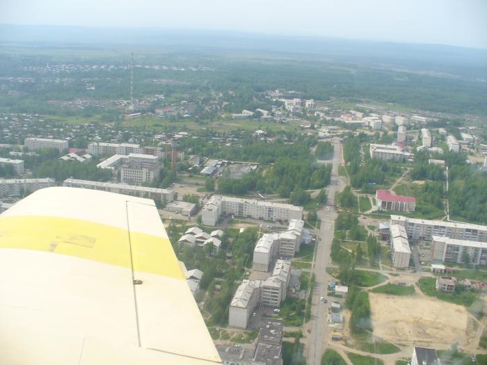
Urban locality (a work settlement) and the administrative center of Verkhnebureinsky District of Khabarovsk Krai, Russia. Population: 13,048 (2010 Census). The settlement is situated in the Bureya River basin, just north of the Baikal-Amur Mainline (BAM). A branch line connects Chegdomyn to Novy Urgal on the BAM. It is located in the valley of the Chegdomyn River, near its confluence with the Urgal. Chegdomyn is located about 340 kilometers (210 mi) northwest of the krai's administrative center of Khabarovsk.
Chegdomyn was founded in 1939, with the beginning of black coal mining in the area. At the same time, construction of a branch line from the Trans-Siberian Railway at Isvestkovaya to Chegdomyn was begun, although it was dismantled during World War II and its tracks reused in construction projects closer to the front. After the end of the war, the railway was rebuilt, opening in 1951. Coal mining resumed in 1948, and Chegdomyn was granted urban-type settlement status in 1949.
Chegdomyn was founded in 1939, with the beginning of black coal mining in the area. At the same time, construction of a branch line from the Trans-Siberian Railway at Isvestkovaya to Chegdomyn was begun, although it was dismantled during World War II and its tracks reused in construction projects closer to the front. After the end of the war, the railway was rebuilt, opening in 1951. Coal mining resumed in 1948, and Chegdomyn was granted urban-type settlement status in 1949.
Wikipedia article: http://en.wikipedia.org/wiki/Chegdomyn
Nearby cities:
Coordinates: 51°8'3"N 132°59'34"E
- Fevralsk 211 km
- Arkhara 280 km
- Progress 284 km
- Seryshevo 324 km
- Sunwu Township 449 km
- Magdagachi 555 km
- Xinlinzhen 602 km
- Xiaoyangqizhen 613 km
- Jagdaqi 632 km
- Jagdaqi 632 km
- Forgotten airport 3.8 km
- Dusse-Alin Tunnel 51 km