Beberibe - Ceará - Brasil
Brazil /
Ceara /
Beberibe /
World
/ Brazil
/ Ceara
/ Beberibe
World / Brazil / Ceará / Beberibe
city, municipality


Beberibe is a municipality in the state of Ceará in Brazil. It's estimated population in 2006 is 46,439.
The current mayor (Prefeito) of Beberibe is Marcos de Queiroz Ferreira. His term ends in 2008. The municipality was created on June 5, 1892, and incorporated July 18, 1892. The name 'Beberibe' means "where the sugar cane grows".
Geography
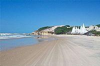
The headquarters of the municipality are located in the town of Beberibe, which is situated about 80km SE of Fortaleza, the state capital of Ceará. Near the town of Beberibe, and extending south-east along the coastline, are many magnificent beaches, popular with tourists. Sports such as kitesurfing are also popular at many of these beaches.
The municipality is divided into several rural districts, aside from the municipal seat of the township of Beberibe. The districts are Parajuru, Paripueira, Itapeim, Sucatinga, and Serra do Félix. The districts are named after the major towns in them.
History
The first register of Beberibe is in 1691, when a small cluster of buildings were built on the "sesmaria" given to Manuel Nogueira Cardoso, Sebastião Dias Freire, João Carvalho Nóbrega and Capitão Domingos Ferreira Chaves.
But it was not until the start of the 19th Century that the village became occupied, when Baltazar Ferreira do Vale, a resident of Riacho Fundo, in Cascavel, and Pedro Queiroz Lima, a resident from the farm of Mirador, in Aquiraz, bought farms there. The farm of Baltazar was suitable for population, and the town of Beberibe developed from there.
The area around Beberibe was originally named Uruanda by the native peoples of Brazil, and Beberibe was the name of the plot of land owned by Brasiliano Ferreira de Araújo, which is currently the site of the city's municipal headquarters. Brasiliano donated some of this land for the construction of the local church, which encouraged rapid growth of the town. The church was inaugurated in 1875, by which time the town was widely known as Beberibe. The Municipality of Beberibe was created in 1892, and fell in the judicial district of Cascavel.
However, the status of Beberibe as a Municipality or a District continually changed up until 1951, when, petitioned by Appeals Court judge Boanerges Facó, the governor Raul Barbosa passed a law establishing Beberibe as a municipality, and the autonomy which came with such a designation. It was not until 1955, however, that the Municipality was officially installed.
Beberibe, as its name origin may suggest, experienced rapid economic growth as a result of the construction of numerous sugar mills in the region. The wealth which was produced by the rapadura industry led to the city being nicknamed "Vila Rica" (Rich Town). Many mills have now gone bankrupt, and the rapadura industry declined, so the name no longer applies.
Coordinates: 4°11′S, 38°08′W
The current mayor (Prefeito) of Beberibe is Marcos de Queiroz Ferreira. His term ends in 2008. The municipality was created on June 5, 1892, and incorporated July 18, 1892. The name 'Beberibe' means "where the sugar cane grows".
Geography
The headquarters of the municipality are located in the town of Beberibe, which is situated about 80km SE of Fortaleza, the state capital of Ceará. Near the town of Beberibe, and extending south-east along the coastline, are many magnificent beaches, popular with tourists. Sports such as kitesurfing are also popular at many of these beaches.
The municipality is divided into several rural districts, aside from the municipal seat of the township of Beberibe. The districts are Parajuru, Paripueira, Itapeim, Sucatinga, and Serra do Félix. The districts are named after the major towns in them.
History
The first register of Beberibe is in 1691, when a small cluster of buildings were built on the "sesmaria" given to Manuel Nogueira Cardoso, Sebastião Dias Freire, João Carvalho Nóbrega and Capitão Domingos Ferreira Chaves.
But it was not until the start of the 19th Century that the village became occupied, when Baltazar Ferreira do Vale, a resident of Riacho Fundo, in Cascavel, and Pedro Queiroz Lima, a resident from the farm of Mirador, in Aquiraz, bought farms there. The farm of Baltazar was suitable for population, and the town of Beberibe developed from there.
The area around Beberibe was originally named Uruanda by the native peoples of Brazil, and Beberibe was the name of the plot of land owned by Brasiliano Ferreira de Araújo, which is currently the site of the city's municipal headquarters. Brasiliano donated some of this land for the construction of the local church, which encouraged rapid growth of the town. The church was inaugurated in 1875, by which time the town was widely known as Beberibe. The Municipality of Beberibe was created in 1892, and fell in the judicial district of Cascavel.
However, the status of Beberibe as a Municipality or a District continually changed up until 1951, when, petitioned by Appeals Court judge Boanerges Facó, the governor Raul Barbosa passed a law establishing Beberibe as a municipality, and the autonomy which came with such a designation. It was not until 1955, however, that the Municipality was officially installed.
Beberibe, as its name origin may suggest, experienced rapid economic growth as a result of the construction of numerous sugar mills in the region. The wealth which was produced by the rapadura industry led to the city being nicknamed "Vila Rica" (Rich Town). Many mills have now gone bankrupt, and the rapadura industry declined, so the name no longer applies.
Coordinates: 4°11′S, 38°08′W
Wikipedia article: http://en.wikipedia.org/wiki/Beberibe
Nearby cities:
Coordinates: 4°21'36"S 38°5'17"W
- Aracati - Ceará - Brasil 13 km
- Baraúna - Rio Grande do Norte - Brasil 67 km
- Mossoró 81 km
- Governador Dix-Sept-Rosado 100 km
- Jaguaribara 132 km
- Assu 145 km
- Macau - RN 168 km
- São Gonçalo do Amarante - Ceará - Brasil 169 km
- Pedro Avelino - Rio Grande do Norte - Brasil 205 km
- Trairi 207 km
- Nova Lake 6.3 km
- Funda Lake 10 km
- Dentro Lake 13 km
- Uruaú Lake 15 km
- Boqueirão Cesário 29 km
- Barbada Lake 38 km
- Açude Pacajus - Ceará - Brasil 41 km
- Palhano (Seat) 45 km
- Cemetery 65 km
- Canafístula’s lagoon 79 km