U-2359
Denmark /
Nordjylland /
Saeby /
World
/ Denmark
/ Nordjylland
/ Saeby
World / Sweden / Västra Götaland
Second World War 1939-1945, ship wreck, submarine, invisible
After 12 years of searching for U-2359, four divers discovered the submarine with its bow pointed directly into the sea floor on a 30 degree angle with the ability to dive under the stern. Suppose one could call this a real nosedive.
The actual location of U-2359 is not public yet.
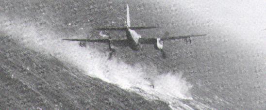
Position (approx.) 57.29 N, 11.24 E, sunk May 2, 1945, by rockets from British Mosquito aircraft (Sqdn. 143, 235 & 248), Norwegian Mosquito aircraft (Sqdn. 333) and Canadian Mosquito aircraft (RCAF 404). 12 dead (all hands lost).
The actual location of U-2359 is not public yet.
Position (approx.) 57.29 N, 11.24 E, sunk May 2, 1945, by rockets from British Mosquito aircraft (Sqdn. 143, 235 & 248), Norwegian Mosquito aircraft (Sqdn. 333) and Canadian Mosquito aircraft (RCAF 404). 12 dead (all hands lost).
Nearby cities:
Coordinates: 57°17'26"N 11°14'26"E
- Zaozersk Munitions Depot 1694 km
- Place of sinking К-278 "Коmsomolets" 1835 km
- S-80 1852 km
- Graham Island 2242 km
- Turkish Naval Base 2287 km
- U-852 (wreck) 6308 km
- Puam-Dong Submarine Base 7656 km
- Kuril-Kamchatka Trench 7905 km
- Wreck of USS Grenadier (SS-210) 9193 km
- Wreck of HIJMS I-45 10566 km
- Konti-Skan Laeso Terminal 7.2 km
- Læsø Mast 12 km
- Læsø 13 km
- Airport 14 km
- Taxiway 14 km
- Laeso Airport 15 km
- Runway 06/24 15 km
- havstien 19 km
- Konti-Skan Laeso Cable Terminal 21 km
- Læsø Rende 32 km