Malika Parbat (17,356 ft)
Pakistan /
Azad Kashmir /
Muzaffarabad /
Saifal Malook Jheel
World
/ Pakistan
/ Azad Kashmir
/ Muzaffarabad
World / Pakistan / N.W.F.P. / Hazara
mountain
Add category

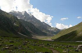
Malka-Parbat is the highest peak in the Hzara Division, in the North-West Frontier Province of Pakistan. Its elevation is 17,356 Ft above sea Level and it over-shadows the legendary Lake Saif-Ul-Muluk which in it-self is at an altitude of 9000 Ft. The nearest major village is Naran (Kaghan valley). This peak can be ascended by several routes, the most easy being the route following Lalazar, which on a straight road from Naran is about 20km and once you reach Lalazar from Naran, you can further up your climb through lush green meadows to all of a sudden rocky and snow covered peaks.
Wikipedia article: http://en.wikipedia.org/wiki/Malika_Parbat
Nearby cities:
Coordinates: 34°49'35"N 73°43'32"E
- Kachh Gali Mountains 14 km
- Beautiful Mountains 30 km
- Musa ka Musalla 36 km
- Shamshabari Range 53 km
- Bungus Valley 56 km
- Mazeno Ridge 85 km
- Gangs Singy 161 km
- Malubiting Massif (Max. Elevation of several peaks 7453 m) 170 km
- Palgad 187 km
- Tupopdan mountain ridge (highest point 6106 m) 221 km
- Lake Saiful Maluk 6.3 km
- Dumping Ground Naran (KgDA) 11 km
- Mahandri Takia 19 km
- till harru 21 km
- Danna Meadows 23 km
- Bhoonja 29 km
- Sari Bhoonja 29 km
- Siri Paye Meadows 32 km
- ghanool 36 km
- Azad Jammu and Kashmir 106 km
Comments