Ayrk
Armenia /
Gegharkunik /
Akunk /
World
/ Armenia
/ Gegharkunik
/ Akunk
World / Armenia
village
Add category
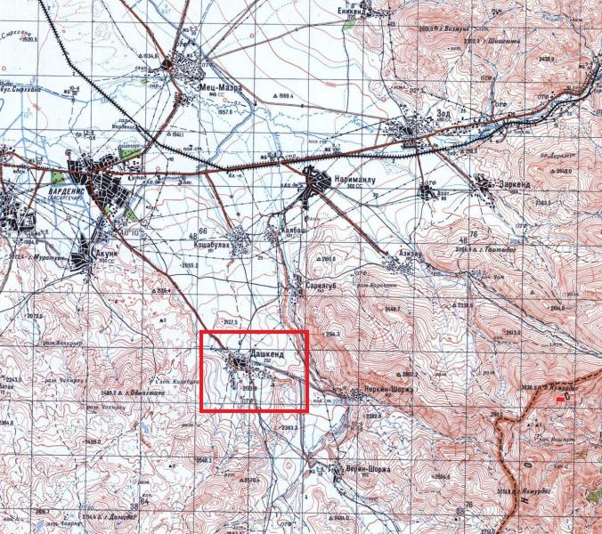
Ayrk (Armenian: Այրք) or Dashkend (Azerbaijani: Daşkənd) is a village in the Gegharkunik Province of Armenia. Founded at early Middle ages as Armenian village named Ayrk' in Gegharkunik gavar (district) of Syunik ashkhar (province) of Greater Armenia's kingdom. Population was deported to Persia by Abbas 1-st in 1603, then nomadic Turkic tribes from Middle Asia settled this and many other emptied Armenian settlements. By 19th century there was a Caucasian Tatar inhabited village known by name Dashkend name wich means "Town of Stone" in Turkish. Since the 1936 population census shows the village is populated by Azeris. According to Azerbaijani sources in 1948 part of the population was deported by Soviet army. In this period Azerbaijani musicians - Alghayit, Najaf, Sarraf Siruya, Hasan was born there. After the Karabakh conflict broke, in 1988 remained Azerbaijani population sold their homes to Armenian refuges from Soviet Azerbaijan and left the village. Since the 1989 gets back the historical name Ayrk. The village contains the Church of St. Astvatsatsin dated to 1181 AD, and the 13th-century Katoghike St. Gevorg church, 150 meters apart from each other. Both churches have large adjoining cemeteries, and between them are the remains of massive stone walls of an Iron Age fortification with shallow caves below.
Wikipedia article: http://en.wikipedia.org/wiki/Ayrk
Nearby cities:
Coordinates: 40°7'14"N 45°47'30"E
- Akunk 8.5 km
- Sotk 11 km
- Mets Masrik 13 km
- Elyasalilar 29 km
- Başlıbel 31 km
- Kamyshly 35 km
- Zallar 39 km
- Charektar 46 km
- Dastafyur 47 km
- Toğanalı 56 km
- Nerkin Shorzha 4.5 km
- Bovnots mt. (2.480 m) 4.7 km
- Norabak 7 km
- Yeritsasar mt. 8.1 km
- Territory of Armenia felt under Azerbaijan control on September 14, 2022 9 km
- Territory of Armenia occupied by Azerbaijan 12 May 2021 9 km
- Tashtasar mt. 10 km
- Vardenis District 14 km
- Kalbajar District 31 km
- Armenia - Azerbaijan line of contact 55 km