Radio station
Russia /
Korjakija /
Kamenskoye /
World
/ Russia
/ Korjakija
/ Kamenskoye
, 240 km from center (Каменское)
World / Russia / Chukot
military, tropospheric scatter station, closed / former military


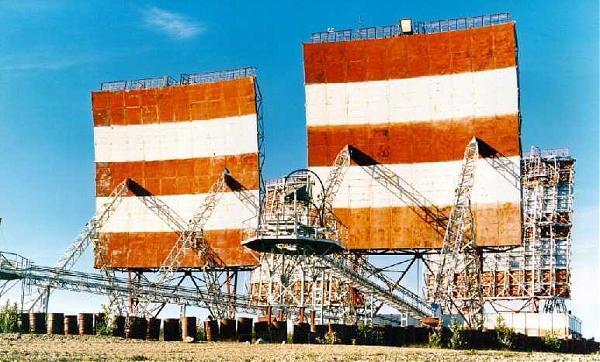

Tropospheric relay station 6/104 "Kiev" . 93365 in / hr
TRRS 6-104 . s. Slautnoe , Koryak Autonomous Okrug . Call sign - "Kiev" . V / h - 93365
"Kiev" intermediate station . In the south- west of it was a station near the village of Kamenka ( "Riga" ) - 156 km, and the north-east - the station in the village. Dawn ( " Bitter " ) - 242 km . The station was located at the confluence of the Black River in the river on the mountain Penzhino Shaman , altitude 357 meters (elevation of the level of the river Penzhina - 230 m) . Distance to p. Ayanka - 31 km, with . Slautnoe - 43 km . Station coordinates 63.557 cw 168.092 bg . Military unit was disbanded in March 1995 , the station itself was a part of the Center
Communication " Riga " as an operational separation "Kiev" . Serviced on a rotational basis , beginning at two weeks , then switched to one month. Closed in 2003.
Nearby cities:
Coordinates: 63°33'11"N 168°5'38"E
Array