Banda Api Island
Indonesia /
Maluku /
Amahai /
World
/ Indonesia
/ Maluku
/ Amahai
World
island, volcano
The small Banda Api island is an active volcano in Banda Sea, which has been observed since the Age of Exploration when the Portuguese Empire and the Kingdom of the Netherlands competed in the area for spice trade. A 7 km wide of mostly submerged caldera is located at the northwest corner of the volcano.
Banda Api
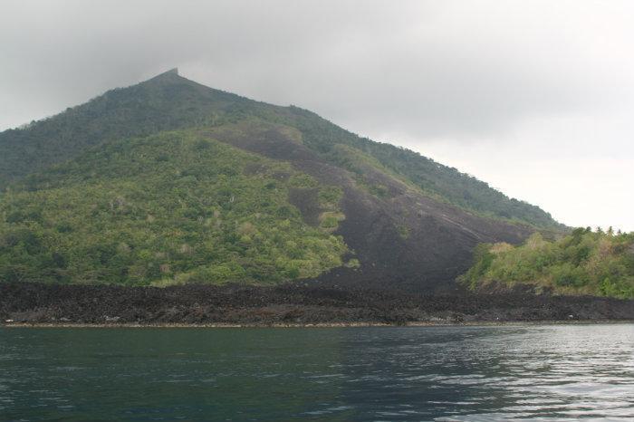
The small island volcano of Banda Api is the NE-most volcano in the Sunda-Banda arc and has a long period of historical observation because of its key location in the thriving Portuguese and Dutch spice trade. The basaltic-to-rhyodacitic Banda Api is located in the SW corner of a 7-km-wide mostly submerged caldera that comprises the northernmost of a chain of volcanic islands in the Banda Sea. At least two episodes of caldera formation are thought to have occurred, with the arcuate islands of Lonthor and Neira considered to be remnants of the pre-caldera volcanoes. Gunung Api forms a conical peak rising to 640 m at the center of the 3-km-wide Banda Api island. Historical eruptions have been recorded since 1586, mostly consisting of strombolian eruptions from the summit crater, but larger explosive eruptions have occurred and occasional lava flows have reached the coast.
www.volcano.si.edu/world/volcano.cfm?vnum=0605-09=
Banda Api
The small island volcano of Banda Api is the NE-most volcano in the Sunda-Banda arc and has a long period of historical observation because of its key location in the thriving Portuguese and Dutch spice trade. The basaltic-to-rhyodacitic Banda Api is located in the SW corner of a 7-km-wide mostly submerged caldera that comprises the northernmost of a chain of volcanic islands in the Banda Sea. At least two episodes of caldera formation are thought to have occurred, with the arcuate islands of Lonthor and Neira considered to be remnants of the pre-caldera volcanoes. Gunung Api forms a conical peak rising to 640 m at the center of the 3-km-wide Banda Api island. Historical eruptions have been recorded since 1586, mostly consisting of strombolian eruptions from the summit crater, but larger explosive eruptions have occurred and occasional lava flows have reached the coast.
www.volcano.si.edu/world/volcano.cfm?vnum=0605-09=
Wikipedia article: http://en.wikipedia.org/wiki/Banda_Api
Nearby cities:
Coordinates: 4°31'13"S 129°52'47"E
- Banda Besar island 2.6 km
- Pulau Ceram Laut 136 km
- Pulau Pandjang 159 km
- Pulau Manawoka 162 km
- Pulau Parang 168 km
- Pulau Gorom 177 km
- Pulau Kesui 192 km
- Pulau Baam 201 km
- Pulau Tioor 205 km
- Pulau Kur 247 km
- Banda Api Volcano 0.2 km
- Lava Sand 1 km
- Lontor Strait 2.1 km
- Banda Naira Airport 2.9 km
- Lakui Bay 4 km
- The Banda Islands 5.3 km
- Burung strait 6.8 km
- Taman Laut Banda recreation park 7.6 km
- Hatta/Rozengain Reef 24 km
- Banda Sea 201 km