Paldalsan (Suwon)
Korea (South) /
Kyonggi /
Suwon
World
/ Korea (South)
/ Kyonggi
/ Suwon
World / South Korea / Gyeonggi-do
mountain, park


The mountains in the center of Suwon.
Location Suwon
Height 128m
Gyeonggi Suwon is in the center of the city jusan. In the south of the old name on top of the gwanggyosan sanyira the name of the tapsaneuro bulryeotgo now called since the start of the Korean King Taejo. Beautiful in the city center, across the mountains and eight months in 1974 was designated as a park. "Suwon eupji copy" in the Department of Suwon is jusan is a lot of spots, he has written.
In the past, it has been renamed bulryeotneunde tapsanyirago the scholar is considered gongminwang (Lee皋) is associated with. Retired and left the world I lived in the mountains gongyangwang people asked to send updates, "the beautiful scenery tapsanui behind the house rises to the summit satongpaldal do not have anything to cover the heart and eyes, having fun," he has had the answer. To the right is the official position of the King Taejo gwonhaja was refused. The chemical industry had come up, drawn tapsaneul see a picture of King Taejo "It holds eight fornication mountain," he should have been called a place in the mountains paldalsan.
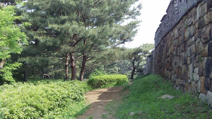
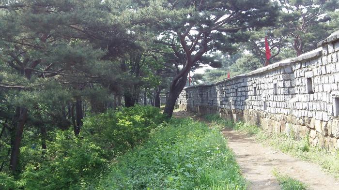
Although the city, but at the top of the mountain in the low-rise, the view east from west teuyeo the entire flick is a cool perspective. Along the mountain ridge and chukjodoen Mars hwayangru seoporu seonodae seojangdae facilities is at least preserved their round, unobstructed mountain and harmony to the old-fashioned super jaahnaenda. This is all the view east from west of the Han River seonodaeeseoneun sub. These mountains stand, according to Feng Shui that will be hyeolcheoe of Suwon.
3.2 ㎞ the circulation of the mountain road and 3 yaksuteo, various sports facilities and walking trails, including a mounted statue of General ganggamchan, hongnanpa noraebi, 3.1 movement monuments, and the kinds of hyowon is installed. 6.25 During the war, almost destroyed the forest, but the beginning of 1960, started planting trees, has reached today.
> swap
Location Suwon
Height 128m
Gyeonggi Suwon is in the center of the city jusan. In the south of the old name on top of the gwanggyosan sanyira the name of the tapsaneuro bulryeotgo now called since the start of the Korean King Taejo. Beautiful in the city center, across the mountains and eight months in 1974 was designated as a park. "Suwon eupji copy" in the Department of Suwon is jusan is a lot of spots, he has written.
In the past, it has been renamed bulryeotneunde tapsanyirago the scholar is considered gongminwang (Lee皋) is associated with. Retired and left the world I lived in the mountains gongyangwang people asked to send updates, "the beautiful scenery tapsanui behind the house rises to the summit satongpaldal do not have anything to cover the heart and eyes, having fun," he has had the answer. To the right is the official position of the King Taejo gwonhaja was refused. The chemical industry had come up, drawn tapsaneul see a picture of King Taejo "It holds eight fornication mountain," he should have been called a place in the mountains paldalsan.
Although the city, but at the top of the mountain in the low-rise, the view east from west teuyeo the entire flick is a cool perspective. Along the mountain ridge and chukjodoen Mars hwayangru seoporu seonodae seojangdae facilities is at least preserved their round, unobstructed mountain and harmony to the old-fashioned super jaahnaenda. This is all the view east from west of the Han River seonodaeeseoneun sub. These mountains stand, according to Feng Shui that will be hyeolcheoe of Suwon.
3.2 ㎞ the circulation of the mountain road and 3 yaksuteo, various sports facilities and walking trails, including a mounted statue of General ganggamchan, hongnanpa noraebi, 3.1 movement monuments, and the kinds of hyowon is installed. 6.25 During the war, almost destroyed the forest, but the beginning of 1960, started planting trees, has reached today.
> swap
Nearby cities:
Coordinates: 37°16'41"N 127°0'39"E
- Baegunsan 10 km
- Cheonggyesan 19 km
- Gwanaksan 22 km
- Bukhansan 47 km
- Cheonmasan 53 km
- Yongmunsan 57 km
- Gwangdeoksan 59 km
- Gayasan 68 km
- Daeyasan 101 km
- Johangsan 104 km
- Namchang-dong 0.3 km
- Sinpung-dong 0.6 km
- Hwaseong Fortress 0.7 km
- Hwaseo-dong, 71 0.7 km
- Gyo-dong 0.8 km
- Godeung-dong 0.8 km
- Maesan-ro 3-ga 0.8 km
- Blooming Pureunsup Apartments 1.1 km
- Hwaseo-dong, 250 1.1 km
- Hwaseo-dong 1.6 km