ডুমুরিয়া উপজেলা সদর
Bangladesh /
Khulna /
World
/ Bangladesh
/ Khulna
/ Khulna
/ ভারত / পশ্চিমবঙ্গ / উত্তর চব্বিশ পরগণা জেলা
township (en), উপজেলা, fourth-level administrative division (en), local government (en)
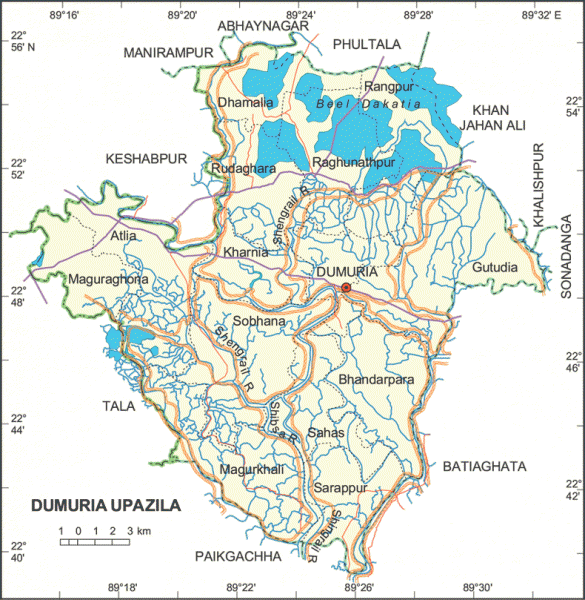
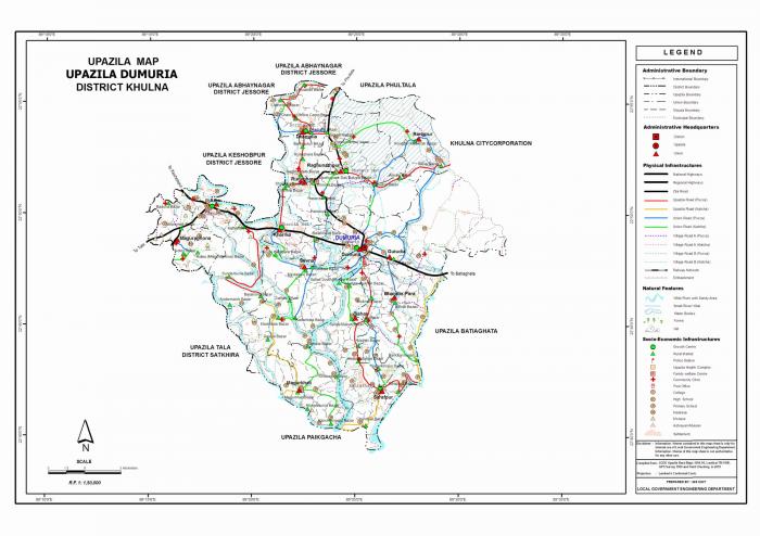
Dumuria Upazila (Khulna district) with an area of 454.23 sq km. is bounded by Manirampur, Abhaynagar and Phultala upazilas on the north, Batiaghata and Paikgachha upazilas on the south, Khan jahan ali, Khalishpur and Sonadanga thanas and Batiaghata upazila on the east, Tala and Keshabpur upazilas on the west. Main rivers are Shibsa and Shengrail; Beel Dakatia is notable.
The location of the Dumuria town is 22.8074082N 89.4211471E. Dumuria (Town) consists of 4 mouzas with an area of 6.93 sq km. It has a population of 14189; male 52.09%, female 47.91%; density of population is 2047 per sq km. The literacy rate among the town people is 44.4%.
Dumuria thana was established in 1918 and was turned into an upazila in 1983. It consists of 14 union parishads 183 mouzas 230 villages.
As of the 1991 Bangladesh census: Population 256503; male 51.12%, female 48.88%; Muslim 56.97%, Hindu 42.83%, Christian 0.01%, Buddhist 0.01%, and others 0.09%.
Religious institutions: Mosque 195, temple 125.
Literacy and educational institutions: Average literacy 36.1%; male 45.4%, female 26.5%. Educational institutions: college 7, high school 33, junior school 8, madrasa 46, government primary school 110, non-government primary school 53.
Cultural organisations: Club 85, public library 2, cinema hall 2, drama stage 2, group theatre 10, literary cultural association 14, women's organisation 22, VDP Club 224, Co-operative Society 458.
Main occupations: Agriculture 46.29%, Agricultural labourer 16.77%, wage labourer 4.09%, commerce 12.85%, industry 2.01%, transport 3.24%, service 4.66% and others 10.08%.
Land use: Total cultivable land 31340 hectares, fallow land 3240 hectares; single crop 36.52%, double crop 33.82%, treble crop 29.66%.
Land control: Among the peasants 20% are landless, 28% small, 32% intermediate, and 0.8% rich; cultivable land per head 0.12 hectares.
Fisheries, dairies, poultries Hatchery 1, fishery 12,000, poultry 285, dairy 88.
Communication facilities- Roads: Pucca 61 km, semi pucca 76 km., mud 467 km; waterways 32 nautical mile.
Manufactories: Oil mill, rice mill, flour mill, turmeric mill, pulse mill, ice factory, fish production centre.
Cottage industries: Handloom 510, bamboo work 305, ironsmith 121, potteries 211, wood work 165, goldsmith 28, bidi factory 1.
NGO activities: brac, Prodipan, proshika, asa, caritas, Nijera Kari, URDEP, Gonoshahajjo Sangstha, CSS, CARE, Progoti.
Health centres: Upazila health complex 1, hospital 2, health and family welfare centre 8.
Nearby cities:
স্থানাঙ্ক: 22°48'17"N 89°25'26"E
- ফকিরহাট উপজেলা সদর 26 কিঃমিঃ
- অভয়নগর উপজেলা সদর 29 কিঃমিঃ
- কালারোয়া উপজেলা সদর 43 কিঃমিঃ
- কচুয়া উপজেলা সদর 46 কিঃমিঃ
- কয়ড়া উপজেলা সদর 50 কিঃমিঃ
- ঝিকড়্গাছা উপজেলা সদর 51 কিঃমিঃ
- মোরেল্গঞ্জ উপজেলা 55 কিঃমিঃ
- পাথরঘাটা 97 কিঃমিঃ
- সরিষাবাড়ি উপজেলা 228 কিঃমিঃ
- গোবিন্দগঞ্জ উপজেলা 271 কিঃমিঃ
- ডুমুরিয়া বাজার 0.8 কিঃমিঃ
- Tuhin's House 4.3 কিঃমিঃ
- শোভনা গাবতলা মাঠ 4.5 কিঃমিঃ
- শোভনা ইউনিয়ন পরিষদ 5.5 কিঃমিঃ
- শোভনা বিরাজময়ী মাধ্যমিক বিদ্যালয় (Add by MS) 6.1 কিঃমিঃ
- শোভনা গোডাউন (Add by MK) 7 কিঃমিঃ
- খনিয়া Bridge 7.8 কিঃমিঃ
- শোভনা পশ্চিম পাড়া ফুটবল মাঠ 7.9 কিঃমিঃ
- ডাকাতিয়া বিল 12 কিঃমিঃ
- খুলনা বিভাগ 14 কিঃমিঃ
Comments