Uruapan
Mexico /
Michoacan /
Uruapan /
World
/ Mexico
/ Michoacan
/ Uruapan
World / Mexico / Michoacán
city
Add category
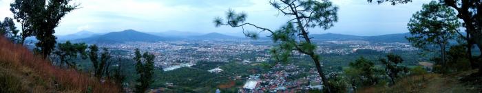
Uruapan is the second largest city in the Mexican state of Michoacán. It is located at the western edge of the Purépecha highlands, just to the east of the Tierra Caliente region. Since the colonial period, it has been an important city economically due its location. The city was conquered by the Spanish in 1522, when the last Purépecha ruler fled the Pátzcuaro area to here. The modern city was laid out in 1534 by Friar Juan de San Miguel. It played an important role in the War of Independence, and was the capital of Michoacán during the French Intervention. Today it is the center of Mexico's avocado growing region, with most of the crop distributed from here nationally and internationally.
Wikipedia article: http://en.wikipedia.org/wiki/Uruapan
Nearby cities:
Coordinates: 19°24'17"N 102°2'38"W
- Lazaro Cardenas 157 km
- Irapuato 164 km
- Silao 186 km
- Guanajuato City 199 km
- Greater León 203 km
- Greater Guadalajara 225 km
- Manzanillo 250 km
- Aguascalientes 284 km
- Puerto Vallarta 367 km
- Tepic 386 km
- Pareo 43 km
- Patamban 51 km
- Purepero 56 km
- Cerro Azul 58 km
- Cerro Tamandaro 59 km
- Presa Orepetiro 63 km
- Tlazazalca 63 km
- Tacátzcuaro 64 km
- Cerrito de la Estación 64 km
- Cerro Cuates 65 km