Hromkla
| temple, university, church, christianity, cemetery, fortress, Medieval / Middle Ages, destroyed, interesting place, Armenian Apostolic church, place of worship
Turkey /
Sanliurfa /
Halfeti /
World
/ Turkey
/ Sanliurfa
/ Halfeti
World / Turkey / Gaziantep
temple, university, church, christianity, cemetery, fortress, Medieval / Middle Ages, destroyed, interesting place, Armenian Apostolic church, place of worship

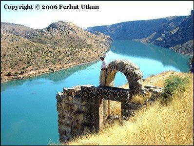
The Qal'at ar-Rum (Arabic: قلعة الروم) was a powerful fortress on the river Euphrates, 50 km west of Şanlıurfa. It is called Hromkla in Kurdish, Rumkale in Turkish, Hromgla in Armenian,; the term meaning "Roman Castle (by extension also Byzantine)" in all cases.
Its strategic location was already known to the Assyrians, although the present structure is largely Hellenistic and Roman in origin. The site was part of Byzantine Empire and Armenian Kingdom of Cilicia during the Middle Ages. Hromkla served as the seat of an Armenian patriarch from the 12th century. From 1203 to 1293 it was the residence of the supreme head (catholicos) of the reunified Armenian church. In 1293 it was captured by the Mamluks of Egypt following a protracted siege.
Its strategic location was already known to the Assyrians, although the present structure is largely Hellenistic and Roman in origin. The site was part of Byzantine Empire and Armenian Kingdom of Cilicia during the Middle Ages. Hromkla served as the seat of an Armenian patriarch from the 12th century. From 1203 to 1293 it was the residence of the supreme head (catholicos) of the reunified Armenian church. In 1293 it was captured by the Mamluks of Egypt following a protracted siege.
Wikipedia article: http://en.wikipedia.org/wiki/Rumkale
Nearby cities:
Coordinates: 37°16'14"N 37°50'17"E
- Սիս / Sis (Sso Berd) 181 km
- Ruines of Surb Nishan monastery 288 km
- Kes 414 km
- Church Kamrak Vank ( St.Thomas) 460 km
- Adır (Lim) Island 514 km
- Spitak monastery 519 km
- Khtzkonk monastery 591 km
- Horomos monastic complex 618 km
- Surb Hakob of Akori - Armenian monastery & cemetery 632 km
- Mother See of Holy Etchmiadzin 646 km
- Boats to Rumkale 0.4 km
- old haltefi منارهای در اب 1.6 km
- Minaret (semi-submerged) 12 km
- Birecik Rreservoir 14 km
- Roman Bridge 19 km
- Gaziantep Province 54 km
- Adıyaman Province 75 km
- Kahramanmaraş Province 104 km
- Şanlıurfa Province 106 km
Comments