Toole Army Depot
USA /
Utah /
Ophir /
South Main Street, 1729
World
/ USA
/ Utah
/ Ophir
World / United States / Utah
arsenal / weapon and ammunition storage, United States Army
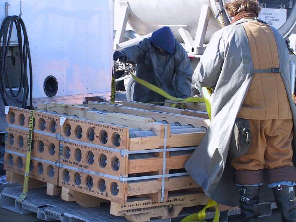
The South Area of the Tooele Depot, also called the Deseret Chemical Depot, is an ammunition storage facility that is home to 42.3% of the nation's chemical weapons. The nearly 30 million pounds of aging mustard and nerve agents are stored in 208 igloos at the facility, awaiting disposal, according to international treaties. Near the igloo field is the Tooele Chemical Agent Disposal Facility incinerator, completed in 1994 at a cost of several hundred million dollars. The controversial disposal plant started burning the chemical weapons at the depot in August, 1996. The incinerator is operated by the EG&G corporation, and it is the first of several incinerators the Army proposes to construct at military facilities across the country, wherever chemical weapons are stored.
All disposal operations concluded January 21, 2012.On July 16, 2013 The Deseret Chemical Depot was renamed Toole Army Depot after the transfer.
www.cma.army.mil/tooele.aspx
www.army.mil/article/107472/Deseret_Chemical_Depot_clos...
All disposal operations concluded January 21, 2012.On July 16, 2013 The Deseret Chemical Depot was renamed Toole Army Depot after the transfer.
www.cma.army.mil/tooele.aspx
www.army.mil/article/107472/Deseret_Chemical_Depot_clos...
Wikipedia article: http://en.wikipedia.org/wiki/Deseret_Chemical_Depot
Nearby cities:
Coordinates: 40°17'51"N 112°20'36"W
- Former Chemical Weapon Storage 4.3 km
- Weapons and Munitions storage 30 km
- Ammunition Storage bunkers 32 km
- Tooele Army Depot 32 km
- Clover Reservoir and WMA 6.6 km
- Clover 10 km
- Jacob City (silver mining) 12 km
- Old Toll Road 12 km
- Barrick Mercur Reservation Cnyn Tailings 13 km
- Indian Hill 13 km
- Five Mile Pass Recreation Area 15 km
- Flat Top Mountain, Utah, 10,620 15 km
- Rush Lake 16 km
- Onaqui Mountains 19 km
Comments