Garrin Mountain
Iran /
Lorestan /
Alashtar /
World
/ Iran
/ Lorestan
/ Alashtar
, 19 km from center (الشتر)
World / Iran / Lorestan
mountain, park, region, invisible


there is mounth of azgros ih famast ih Nahāvand in Hamadan Province in Iran.
کوه گرین از رشته کوهای زاگرس واقع در جنوب رستای فاماست نهاوند و 23 کیلومتری شمال الشتر
لرستان است
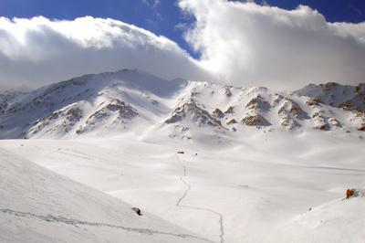
خط الراس گرین با طول بیش از ۳۵ کیلومتر مابین شهرستان های نهاوند- الشتر و بروجرد قرار گرفته است این خط الراس زیبا و بکر به خاطر شرایط خاص جغرافیایی دارای زمستان های بسیا پر برف و طولانی و یخچال های دایمی میباشد که در نوع خود کم نظیر است . از جمله می توان به یخچال گاو ماهی در قله چهل نابالغان اشاره نمود که در تمام طول سال دارای برف است. از بلند ترین قلل منطقه گرین می توان به یال کبود- چهل نابالغان- بازگیر- ولاش و هجده یال اشاره کرد. مبداء صعود به قله ی زیبای یال کبود با ارتفاع تقریبی ۳۸۰۰ متر در سراب گاماسیاب در ۲۵ کیلومتری شهرستان نهاوند و در محور نهاوند- نورآباد قرار دارد
Nahavand - GARIN RIDGE
Garin ridge with more than 35 kilometers long stand in southwest of Nahavand town and is amid three towns: Nahavand¸ Alashtar and Broujerd. This ridge is a section of Zagros Mountain range and contains more than 30 peaks over 3500meters height. For example: Yalkaboud- Chehel Nabaleghan- Bazgir- Hejdah Yal - Velash and
Garin has long with heavy snow winters and permanent glaciers because of special
geographical situation. for example: Gâv - Mâhi glacier . That is interesting natural
phenomenon
In fact Gâv-Mâhi are two separate glaciers. The reason for naming them [Gâv(Cow) Mâhi(Fish)] is that they bear a resemblance to two huge animals: cow & fish. This natural phenomenon is visible in late spring and early summer
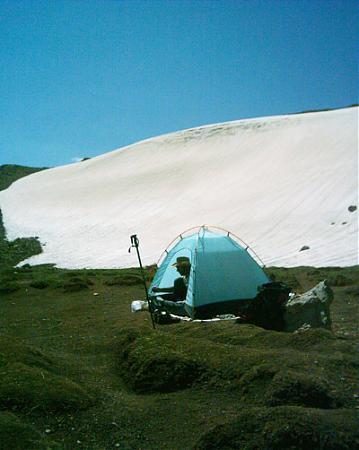
In order to climb Chehel Nabaleghan and Gâv-Mâhi glaciers¸ you have to start your climbing from Garin toll-house¸ about 30kms away from Nahavand¸ on Nahavand – Noorabad road. Chehel Nabaleghan hasn’t any shelters¸ therefore climbing this mountain is usually possible in the daytime
In the past¸ Chehel Nabaleghan had a great value for people in the suburb and especial Nahavand from religious beliefs point of view. The people believed that some 40 offspring of Imams were buried there and every year people who had ability to climb¸ went to these SHRINES. Nowadays we can see signs of these tombs at the peak
Yalkabud peak with more than 3700 meters height is one of the highest mountains of Garin Mount of Zagros Mountain range with 3 shelters two of them in height of 2300meters and the last in 3150meters¸ near of Yalkaboud .
The start point for climbing Yalkaboud peak is Gâmâsiâb will-o-the-wisp 25km away from Nahavand . The best time for climbing Garin because of plenty water and various beautiful vegetation is in summer especially in May and June
If you climb Yalkaboud at night you can see a very beautifu sight of Nahavand and surrounding villages
. product by: Amin Moein
Acknowledgment
With thanks to : Mr.N.Shabazi
.
کوه گرین از رشته کوهای زاگرس واقع در جنوب رستای فاماست نهاوند و 23 کیلومتری شمال الشتر
لرستان است
خط الراس گرین با طول بیش از ۳۵ کیلومتر مابین شهرستان های نهاوند- الشتر و بروجرد قرار گرفته است این خط الراس زیبا و بکر به خاطر شرایط خاص جغرافیایی دارای زمستان های بسیا پر برف و طولانی و یخچال های دایمی میباشد که در نوع خود کم نظیر است . از جمله می توان به یخچال گاو ماهی در قله چهل نابالغان اشاره نمود که در تمام طول سال دارای برف است. از بلند ترین قلل منطقه گرین می توان به یال کبود- چهل نابالغان- بازگیر- ولاش و هجده یال اشاره کرد. مبداء صعود به قله ی زیبای یال کبود با ارتفاع تقریبی ۳۸۰۰ متر در سراب گاماسیاب در ۲۵ کیلومتری شهرستان نهاوند و در محور نهاوند- نورآباد قرار دارد
Nahavand - GARIN RIDGE
Garin ridge with more than 35 kilometers long stand in southwest of Nahavand town and is amid three towns: Nahavand¸ Alashtar and Broujerd. This ridge is a section of Zagros Mountain range and contains more than 30 peaks over 3500meters height. For example: Yalkaboud- Chehel Nabaleghan- Bazgir- Hejdah Yal - Velash and
Garin has long with heavy snow winters and permanent glaciers because of special
geographical situation. for example: Gâv - Mâhi glacier . That is interesting natural
phenomenon
In fact Gâv-Mâhi are two separate glaciers. The reason for naming them [Gâv(Cow) Mâhi(Fish)] is that they bear a resemblance to two huge animals: cow & fish. This natural phenomenon is visible in late spring and early summer
In order to climb Chehel Nabaleghan and Gâv-Mâhi glaciers¸ you have to start your climbing from Garin toll-house¸ about 30kms away from Nahavand¸ on Nahavand – Noorabad road. Chehel Nabaleghan hasn’t any shelters¸ therefore climbing this mountain is usually possible in the daytime
In the past¸ Chehel Nabaleghan had a great value for people in the suburb and especial Nahavand from religious beliefs point of view. The people believed that some 40 offspring of Imams were buried there and every year people who had ability to climb¸ went to these SHRINES. Nowadays we can see signs of these tombs at the peak
Yalkabud peak with more than 3700 meters height is one of the highest mountains of Garin Mount of Zagros Mountain range with 3 shelters two of them in height of 2300meters and the last in 3150meters¸ near of Yalkaboud .
The start point for climbing Yalkaboud peak is Gâmâsiâb will-o-the-wisp 25km away from Nahavand . The best time for climbing Garin because of plenty water and various beautiful vegetation is in summer especially in May and June
If you climb Yalkaboud at night you can see a very beautifu sight of Nahavand and surrounding villages
. product by: Amin Moein
Acknowledgment
With thanks to : Mr.N.Shabazi
.
Wikipedia article: https://en.wikipedia.org/wiki/Garrin_Mountain
Nearby cities:
Coordinates: 33°57'33"N 48°24'43"E
- Shixmiri Sadat Plain 25 km
- Goushe Cheharchenar 31 km
- Hazaveh 102 km
- football area 116 km
- Amir Kabir New Town 158 km
- کشتزار دیم 184 km
- Plain filakhos 194 km
- ZARAND 245 km
- Grape orchards 254 km
- Abhar 255 km
- Segar (Sekuzan) Montain 11 km
- پرورش قزل 13 km
- Forty tons 13 km
- گردنه اسپژ 17 km
- peresk paein 17 km
- Hospital 17 km
- کبوده حسن اباد 22 km
- Kazem Abad 24 km
- Brujerd District 30 km
- Sefidkuh Protected Area 51 km