Fort Gorges (Portland, Maine)
| NRHP - National Register of Historic Places, historic site
USA /
Maine /
Cape Elizabeth /
Portland, Maine
World
/ USA
/ Maine
/ Cape Elizabeth
World / United States / Maine
fort, NRHP - National Register of Historic Places, historic site
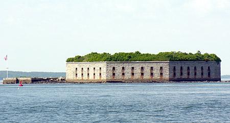
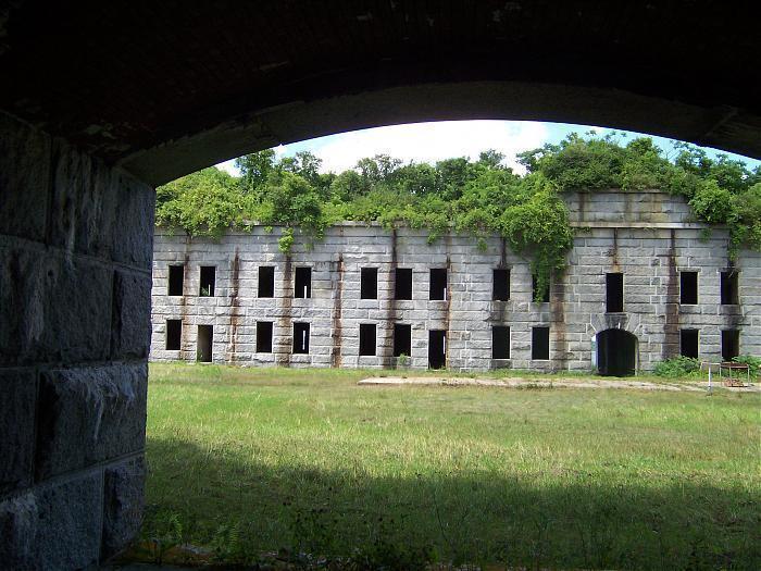
The fort was completed in 1865 as the war ended. Modern explosives made the fort obsolete by the time it was completed. A modernization plan was begun in 1869, but funding was cut off in 1876, with the third level of the fort still unfinished. During the modernization project, sod-covered sand was added to the top level of the fort to protect gun encasements and powder magazines from attacks.
The fort was last used by the military during World War II, when it was used to store submarine mines. It was acquired by the city of Portland in 1960 and placed on the National Register of Historic Places. It is now open to the public as a park, and is accessible only by private boat. Visitors are recommended to carry a flashlight to enter the powder magazines.
Accessing the island involves crossing areas with strong tidal currents and should thus be attempted only under the right conditions, by people with sufficient experience, using a proper boat, i.e. don't try it with a canoe.
Wikipedia article: http://en.wikipedia.org/wiki/Fort_Gorges
Nearby cities:
Coordinates: 43°39'47"N 70°13'17"W
- former boundery wall 5331 km
- former boundary wall 5389 km
- former borderwalls 5418 km
- former boundary wall . 5440 km
- former boundary walls . 5479 km
- former boundary walls 5487 km
- former boundary wall 5492 km
- former borderwall . 5521 km
- former borderwall 5603 km
- Hamaguir former CIEES 5935 km
- Peaks Island 2.6 km
- Great Diamond Island 2.7 km
- Willard 2.8 km
- Cushing Island 3.1 km
- Casco Bay (Southern Section) 3.2 km
- Portland Country Club 5.2 km
- Long Island 6.3 km
- Falmouth Foreside, Maine 7.1 km
- Falmouth, Maine 10 km
- Greater Portland 13 km
Comments