Shag Rocks
Falkland Islands /
South Georgia /
Grytviken /
World
/ Falkland Islands
/ South Georgia
/ Grytviken
World
island, rocks
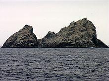
The Shag Rocks are six small islands in the westernmost extreme of South Georgia, 240 km (150 mi) west of the main island of South Georgia and 1000 km (620 mi) off the Falkland Islands.
The Shag Rocks cover a total area of less than 20 hectares (50 acres). Situated on the South Georgia Ridge, they have a peak elevation above sea level of 75 m (246 ft), and stand in water approximately 319 m (1046 ft) deep.
The Shag Rocks cover a total area of less than 20 hectares (50 acres). Situated on the South Georgia Ridge, they have a peak elevation above sea level of 75 m (246 ft), and stand in water approximately 319 m (1046 ft) deep.
Wikipedia article: http://en.wikipedia.org/wiki/Shag_Rocks,_South_Georgia
Nearby cities:
Coordinates: 53°52'42"S 41°36'58"W
- South Georgia 236 km
- Laurie Island 779 km
- Visokoi Island 961 km
- Candlemas Island 1000 km
- Saunders Island 1034 km
- Southern Thule Group (Bellingshausen, Cook, and Thule or Morrell Island) 1060 km
- Thule Island 1062 km
- Montagu Island 1062 km
- Cook Island 1071 km
- Bristol Island 1076 km
- Ice Fjord 257 km
- King Haakon Bay 274 km
- Bay of Isles 282 km
- Jacobsen Bight 313 km
- Cumberland West Bay 330 km
- Thatcher Peninsula 332 km
- Cumberland East Bay 342 km
- Royal Bay 373 km
- South Sandwich Deep 1024 km
- Fosa Meteor 1047 km