Misquamicut State Beach
USA /
Rhode Island /
Westerly /
Atlantic Avenue, 257
World
/ USA
/ Rhode Island
/ Westerly
World / United States / Connecticut
beach, park


Misquamicut State Beach is a state park in Westerly Rhode Island. It is a part of Misquamicut Beach which is a seven mile length of beach that stretches from Weekapaug in the east, westward to Watch Hill, which was called Noyes Beach after Reverend James Noyes from the 18th century to the late 1890s. Watch Hill is also a small district in Washington County. Misquamicut is in southern Washington County and is part of the town of Westerly, Rhode Island. Misquamicut is an Indian word for "Red salmon at this place." Misquamicut is a public state beach where lifeguards are on duty for some of the year. Misquamicut has many swimming and surfing shops, and some of them carry snacks for people on the beach.
The fire district known as Misquamicut was once called Pleasant View, Rhode Island. The land was purchased from Chief Sosoa of the Montauks in 1894. The name was changed from Pleasant View to Misquamicut in 1928.
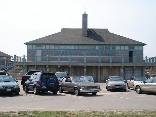
Misquamicut Beach became a state beach in 1959 after the 1954 hurricane had destroyed and forever changed many parts of it. In 1992 State beach area was nearly forced to close when their forty year old septic system broke. The division of parks and beaches was not allowed to build a new septic field so they switched to a waterless form of waste management. Then in 1999 the state of Rhode Island built a 1.5 million dollar bathing pavilion (The James J. Federico Jr. State Beach Pavilion) with heated shower stalls and Clivus Multrum composting toilets. It also included a gift shop, shade gazebos, lifeguard towers and outdoor cold showers. The building project was completed in 2000 with a $700,000 expansion and paving of the parking lot. The lot now holds up to 2700 cars. It is the site of the Misquamicut Music Festival held each year and presented by the Misquamicut Business Association. Featured performers since 2005 have included Jefferson Starship, Davy Jones, Jan and Dean and Eric Burdon and the Animals as well as 2 American Idol contestants.
www.riparks.com/misquamicut.htm
The fire district known as Misquamicut was once called Pleasant View, Rhode Island. The land was purchased from Chief Sosoa of the Montauks in 1894. The name was changed from Pleasant View to Misquamicut in 1928.
Misquamicut Beach became a state beach in 1959 after the 1954 hurricane had destroyed and forever changed many parts of it. In 1992 State beach area was nearly forced to close when their forty year old septic system broke. The division of parks and beaches was not allowed to build a new septic field so they switched to a waterless form of waste management. Then in 1999 the state of Rhode Island built a 1.5 million dollar bathing pavilion (The James J. Federico Jr. State Beach Pavilion) with heated shower stalls and Clivus Multrum composting toilets. It also included a gift shop, shade gazebos, lifeguard towers and outdoor cold showers. The building project was completed in 2000 with a $700,000 expansion and paving of the parking lot. The lot now holds up to 2700 cars. It is the site of the Misquamicut Music Festival held each year and presented by the Misquamicut Business Association. Featured performers since 2005 have included Jefferson Starship, Davy Jones, Jan and Dean and Eric Burdon and the Animals as well as 2 American Idol contestants.
www.riparks.com/misquamicut.htm
Wikipedia article: http://en.wikipedia.org/wiki/Misquamicut_State_Beach
Nearby cities:
Coordinates: 41°19'23"N 71°48'8"W
- Orient Beach State Park 46 km
- Hammonasset Beach State Park 64 km
- Horseneck Beach State Reservation 65 km
- Edgartown Great Pond 103 km
- Katama Section of Edgartown, MA 106 km
- Sandy neck 127 km
- Revere Beach 141 km
- Goose Rocks Beach 258 km
- Popham Beach State Park 316 km
- Reid State Park 323 km
- Winnepaug Pond 1.4 km
- Winnapaug Golf & Country Club 2 km
- The Misquamicut Club 2.4 km
- Westerly State Airport 2.8 km
- Weekapaug, Rhode Island 3.5 km
- Westerly, Rhode Island 5.6 km
- Chapman Pond 6.4 km
- Shelter Harbor Golf Club 7.1 km
- New London County, Connecticut 33 km
- Suffolk County, New York 84 km