Air New Zealand Flight 901 Crash Site
| place with historical importance, aircraft crash site
Antarctica /
Sector claimed by New Zealand /
Scott - permanent station of New Zealand /
World
/ Antarctica
/ Sector claimed by New Zealand
/ Scott - permanent station of New Zealand
World
place with historical importance, aircraft crash site
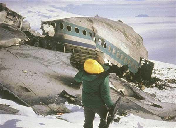
Air New Zealand Flight 901 was a scheduled Air New Zealand Antarctic sightseeing flight that operated from Auckland Airport to Antarctica via Christchurch. Operating McDonnell Douglas DC-10-30 ZK-NZP, Flight 901's crew became disoriented in whiteout conditions and believed they were flying over McMurdo Sound when in fact they were on a collision course with the slopes of Mt. Erebus. While trying to identify visual surface landmarks through breaks in the cloud cover below the aircraft, Flight 901 collided with the mountainside at 1250hrs local time at an altitude of roughly 1,467ft above sea level at this location.
The force of the impact disentegrated the aircraft and instantly killed all 237 passengers and 20 crew aboard the aircraft in what remains New Zealand's deadliest peacetime disaster.
The force of the impact disentegrated the aircraft and instantly killed all 237 passengers and 20 crew aboard the aircraft in what remains New Zealand's deadliest peacetime disaster.
Wikipedia article: http://en.wikipedia.org/wiki/Air_New_Zealand_Flight_901
Nearby cities:
Coordinates: 77°25'29"S 167°27'29"E
- Cape Evans 34 km
- Cape Royds 34 km
- Hut Point 50 km
- Discovery Hut 51 km
- PM-3A Nuclear Reactor 51 km
- "Pegasus" Wreckage 65 km
- Cape Adare 687 km
- Mawson's Huts 1410 km
- Cape Denison 1410 km
- Buromskiy Island 2593 km
- Lewis Bay 12 km
- Tennyson Cape 22 km
- Terror Point 34 km
- Erebus Glacier Tongue 36 km
- MacKay Cape 38 km
- Beaufort Island 54 km
- Dailey Islands 75 km
- Commonwealth Glacier 102 km
- Lake Fryxell 105 km
- Briggs Hill 1210 m 115 km