Johnston Island
USA /
Hawaii /
Kekaha /
World
/ USA
/ Hawaii
/ Kekaha
World / United States Minor Outlying Islands
airport, island, closed / former military

Originally a military base and airfield, the 625.81 acre island was eventually used to dispose of chemical weapons.
In March 1859 Johnston Island was formally claimed by the newly formed Pacific Guano Company, a corporation formed in California to ship guano direct to the west coast, almost immediately involving the United States in brief conflict with the fledgling government of the Kingdom of Hawaii.
The first use of Johnston Island by the U.S. Navy was in 1935, when the personnel of Patrol Wing 2, during the course of patrol-bomber training operations performed some minor construction to develop the atoll for seaplane operation. They erected a few rough buildings and a small boat landing on Sand Island and blasted coral heads within the lagoon to clear a 3600-foot area for use as a runway. A narrow ship-channel was also cut through the reef to afford entrance to the lagoon.
The atoll became contaminated with plutonium through 2 aborted missile launches during high altitude nuclear weapons testing conducted in 1962. Chemical weapons have been stored on Johnston Island since 1971. Beginning in 1990, an extensive operation by the US Army on Johnston Island has performed the deactivation & destruction of 400,000 rockets, bombs, projectiles, mortars, and mines containing chemical weapons. The last of the chemical stockpile was destroyed in 2000. The chemical weapon destruction facilities were closed down in 2002, with the island reverted to being a US Wildlife Refuge in 2008. Johnston Atoll is a part of the Pacific Remote Islands Marine National Monument, which was proclaimed by President George W. Bush on January 6, 2009.
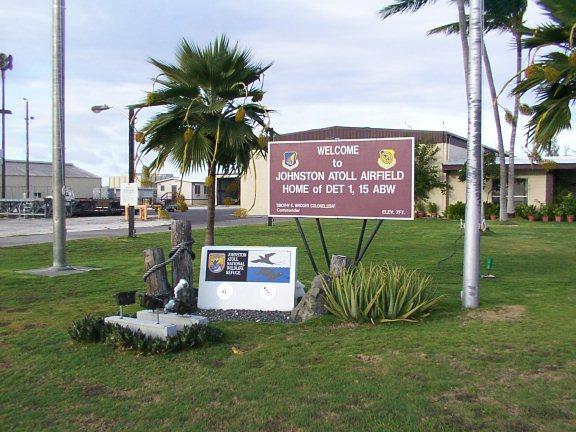
As of 2002, Johnston Atoll Airport is no longer in use as evident by the large X's painted on runway and taxi way.
navypilotoverseas.wordpress.com/2011/05/06/pilot-traini...
members.tripod.com/airfields_freeman/HI/Airfields_W_Pac...
www.janeresture.com/johnston/
Johnston Atoll (16°45'N., 169°31'W.) is about 780 miles WSW of the Island of Hawai‘i. Johnston Atoll consists of four islets that lie on a reef about 9 miles long in a NE-SW direction. Johnston Island, the largest island, lies about 2 miles inside the SW end of the reef. Sand
Island and Hikina Island lie about 1 and 2 miles NE of Johnston Island, respectively; Akau Island is about 1.5 miles N of Sand Island. Johnston Atoll National Wildlife Refuge encompasses all lands and waters within 12 miles from emergent land; the emergent land is currently under the administrative jurisdiction of the U.S. Air Force. Entry to the refuge is strictly prohibited without prior approval from the U.S. Air Force and the Pacific Reefs National Wildlife Refuge Complex (See Appendix A, Department of Interior for address.) Johnston Atoll National Wildlife Refuge is managed as a highly restricted marine reserve to prevent the introduction of invasive species and protect nesting seabirds, sea turtles, other sensitive wildlife and coral reef habitats, and is subject to Federal regulations
(See 50 CFR Parts 25-38 and 665). More information can be found at www.fws.gov/johnstonisland/. Prominent features: The large multi-story Joint Operations Building stands on the NE end of Johnston Island and is very prominent. The outline of the island does not show until within 10 miles of the island. Channels: The main entrance channel is entered S of Johnston Island and leads to the harbor. The harbor consists of a turning basin within the lagoon about midway between Johnston and Sand Islands. In 1964, the entrance channel was dredged to a depth of 35 feet. The turning basin and harbor area have a depth of 35 feet. The berthing area alongside the main pier has a depth of 29.8 feet. Maximum draft for vessels entering the harbor under normal conditions is 28 feet. The largest vessel to enter was 656 feet long. Vessels should not enter at night or when cross channel winds exceed 25 knots. Dangers:
A barrier reef surrounds Johnston Island, and extends in an arc from about 2 miles W to about 7 miles NE of the island. Depths outside the reef drop off to 100 fathoms about 0.4 mile off. With heavy breakers on the reef, a 2 to 3-foot surge exists inside the lagoon. From the NE, via S to SW is a foul area with a very irregular bottom. The 100-fathom curve lies 4 miles S of the center of Johnston Island; however, there are 5-fathom shoals lying as close as 0.3 mile inside the curve and depths shallower than 10 fathoms can be found as far as 10 miles E and 6 miles SE of the Johnston Island.
[www.nauticalcharts.noaa.gov/nsd/coastpilot/files/cp7/CP...]
In March 1859 Johnston Island was formally claimed by the newly formed Pacific Guano Company, a corporation formed in California to ship guano direct to the west coast, almost immediately involving the United States in brief conflict with the fledgling government of the Kingdom of Hawaii.
The first use of Johnston Island by the U.S. Navy was in 1935, when the personnel of Patrol Wing 2, during the course of patrol-bomber training operations performed some minor construction to develop the atoll for seaplane operation. They erected a few rough buildings and a small boat landing on Sand Island and blasted coral heads within the lagoon to clear a 3600-foot area for use as a runway. A narrow ship-channel was also cut through the reef to afford entrance to the lagoon.
The atoll became contaminated with plutonium through 2 aborted missile launches during high altitude nuclear weapons testing conducted in 1962. Chemical weapons have been stored on Johnston Island since 1971. Beginning in 1990, an extensive operation by the US Army on Johnston Island has performed the deactivation & destruction of 400,000 rockets, bombs, projectiles, mortars, and mines containing chemical weapons. The last of the chemical stockpile was destroyed in 2000. The chemical weapon destruction facilities were closed down in 2002, with the island reverted to being a US Wildlife Refuge in 2008. Johnston Atoll is a part of the Pacific Remote Islands Marine National Monument, which was proclaimed by President George W. Bush on January 6, 2009.
As of 2002, Johnston Atoll Airport is no longer in use as evident by the large X's painted on runway and taxi way.
navypilotoverseas.wordpress.com/2011/05/06/pilot-traini...
members.tripod.com/airfields_freeman/HI/Airfields_W_Pac...
www.janeresture.com/johnston/
Johnston Atoll (16°45'N., 169°31'W.) is about 780 miles WSW of the Island of Hawai‘i. Johnston Atoll consists of four islets that lie on a reef about 9 miles long in a NE-SW direction. Johnston Island, the largest island, lies about 2 miles inside the SW end of the reef. Sand
Island and Hikina Island lie about 1 and 2 miles NE of Johnston Island, respectively; Akau Island is about 1.5 miles N of Sand Island. Johnston Atoll National Wildlife Refuge encompasses all lands and waters within 12 miles from emergent land; the emergent land is currently under the administrative jurisdiction of the U.S. Air Force. Entry to the refuge is strictly prohibited without prior approval from the U.S. Air Force and the Pacific Reefs National Wildlife Refuge Complex (See Appendix A, Department of Interior for address.) Johnston Atoll National Wildlife Refuge is managed as a highly restricted marine reserve to prevent the introduction of invasive species and protect nesting seabirds, sea turtles, other sensitive wildlife and coral reef habitats, and is subject to Federal regulations
(See 50 CFR Parts 25-38 and 665). More information can be found at www.fws.gov/johnstonisland/. Prominent features: The large multi-story Joint Operations Building stands on the NE end of Johnston Island and is very prominent. The outline of the island does not show until within 10 miles of the island. Channels: The main entrance channel is entered S of Johnston Island and leads to the harbor. The harbor consists of a turning basin within the lagoon about midway between Johnston and Sand Islands. In 1964, the entrance channel was dredged to a depth of 35 feet. The turning basin and harbor area have a depth of 35 feet. The berthing area alongside the main pier has a depth of 29.8 feet. Maximum draft for vessels entering the harbor under normal conditions is 28 feet. The largest vessel to enter was 656 feet long. Vessels should not enter at night or when cross channel winds exceed 25 knots. Dangers:
A barrier reef surrounds Johnston Island, and extends in an arc from about 2 miles W to about 7 miles NE of the island. Depths outside the reef drop off to 100 fathoms about 0.4 mile off. With heavy breakers on the reef, a 2 to 3-foot surge exists inside the lagoon. From the NE, via S to SW is a foul area with a very irregular bottom. The 100-fathom curve lies 4 miles S of the center of Johnston Island; however, there are 5-fathom shoals lying as close as 0.3 mile inside the curve and depths shallower than 10 fathoms can be found as far as 10 miles E and 6 miles SE of the Johnston Island.
[www.nauticalcharts.noaa.gov/nsd/coastpilot/files/cp7/CP...]
Wikipedia article: http://en.wikipedia.org/wiki/Johnston_Atoll
Nearby cities:
Coordinates: 16°43'44"N 169°32'0"W
- Lihue Airport (PHLI / LIH) 1218 km
- Kalaeloa Airport 1308 km
- Former Naval Air Station Barbers Point 1308 km
- Wheeler Army Airfield 1319 km
- Joint Base Pearl Harbor – Hickam (IATA: HIK – ICAO: PHIK) 1321 km
- Honolulu International Airport (HNL/PHNL) 1322 km
- Marine Corps Base Hawaii 1343 km
- Bellows Air Force Station Military Recreation Area 1345 km
- Kahului International Airport - (OGG / PHOG) 1455 km
- Hilo International Airport (IATA: ITO, ICAO: PHTO) 1565 km
- Runway 5/23 (closed) 0.1 km
- "The Pluto Yard" 0.3 km
- Scientific Row 0.7 km
- Red Hat Storage Area 0.8 km
- Quarry 4 km
- Akau Island (a.k.a. "North Island") 4.1 km
- Quarry 5.3 km
- Hikina Island (a.k.a. "East Island") 5.7 km
- Johnston Atoll 8.9 km
- Starfish Prime 31 km