Killini
| village
Greece /
Ilia /
Killini /
World
/ Greece
/ Ilia
/ Killini
, 1 km from center (Κυλλήνη)
World / Greece / Dytiki Ellada
village
Add category


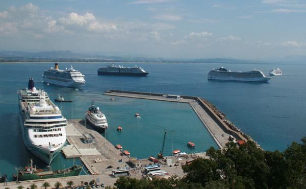


Founded in front of the Ionian coastline, this town has plenty of hotels and villas like the Avocado. A spring south of Kyllini has the same name. The westernmost point of the Peloponnese is one of the most scenic destinations in Elia. Most of the hill is covered with forests and olive trees. The plain covers only about 20% of the land, and Neochori is the only village lying. Most of the area is forested; the remainder is agricultural. The peninsula's westernmost port, the Port of Kyllini is just east of the heart of Kyllini. Restaurants and stores are line up with a street overlooking at the sea.
A military base is located to the southeast, off the Kyllini–Andravida Road, the former GR-84. The base contains luxury-sized houses for refugees. It is surrounded by barbed wire gates. There are no hospitals or health centers. The closest health center is in Varda. A monastery is located in Vlacherna southeast of Kato Panagia. Chlemoutsi, a fortress, was built to protect the invaders from other parts of Europe. Today it is abandoned, and has been turned into a tourist attraction. It sits atop a hill 135 m above sea level and surrounded by pine trees and houses from Kastro. Singers including George Dalaras (Giorgos Ntalaras) have entertained at the fortress.
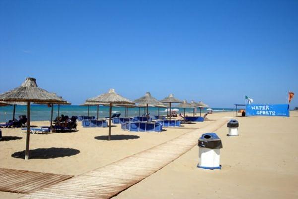
The Thermal Springs of Kyllini (the Kyllini Baths) are the largest beach facility in the western Peloponnese. In the mid-20th century, construction began on opening a spring linking with about 1 km of roads with parking lot 200 to 300 m from the sea with hot-sandy beach. Kyllini is in an earthquake zone. There have been several strong earthquakes in community's history. The most significant recent earthquake was the Ionian Earthquake in 1953, which caused moderate damage.
Cape Kyllini is a cape located north of Kyllini. Between the cape and Kyllini is a small fortress named Glarentza and slightly east is the beach. It also offers a view of the island of Kefallinia from the north. The island of Kafkalida is the only unhabited settlement. The island is rocky and has Kyllini's lighthouse. The lighthouse is about 20 to 30 m tall. It is accessed by a tiny port holding one or two boats and is not used for cars from the port of Kyllini. It is only accessed by a pathway. The northern half of the island are made up of rocks. The island about 100,000 years ago was connected with the mainland.
A military base is located to the southeast, off the Kyllini–Andravida Road, the former GR-84. The base contains luxury-sized houses for refugees. It is surrounded by barbed wire gates. There are no hospitals or health centers. The closest health center is in Varda. A monastery is located in Vlacherna southeast of Kato Panagia. Chlemoutsi, a fortress, was built to protect the invaders from other parts of Europe. Today it is abandoned, and has been turned into a tourist attraction. It sits atop a hill 135 m above sea level and surrounded by pine trees and houses from Kastro. Singers including George Dalaras (Giorgos Ntalaras) have entertained at the fortress.
The Thermal Springs of Kyllini (the Kyllini Baths) are the largest beach facility in the western Peloponnese. In the mid-20th century, construction began on opening a spring linking with about 1 km of roads with parking lot 200 to 300 m from the sea with hot-sandy beach. Kyllini is in an earthquake zone. There have been several strong earthquakes in community's history. The most significant recent earthquake was the Ionian Earthquake in 1953, which caused moderate damage.
Cape Kyllini is a cape located north of Kyllini. Between the cape and Kyllini is a small fortress named Glarentza and slightly east is the beach. It also offers a view of the island of Kefallinia from the north. The island of Kafkalida is the only unhabited settlement. The island is rocky and has Kyllini's lighthouse. The lighthouse is about 20 to 30 m tall. It is accessed by a tiny port holding one or two boats and is not used for cars from the port of Kyllini. It is only accessed by a pathway. The northern half of the island are made up of rocks. The island about 100,000 years ago was connected with the mainland.
Wikipedia article: http://en.wikipedia.org/wiki/Kyllini,_Elis
Nearby cities:
Coordinates: 37°56'4"N 21°8'32"E
- Μyrsini 7.6 km
- Vartholomio 8.5 km
- Tragano 14 km
- Savalia 17 km
- Manolada 22 km
- Lakkopetra 38 km
- Lousika 44 km
- Paralia Alissou 45 km
- Tsoukalaiika 51 km
- Nea Souli 64 km
- Port of Kyllini 0.7 km
- Camping Melissa 6 km
- ROBINSON Club Kyllini Beach 4* 6.5 km
- Loutra Kyllinis 8.7 km
- Grecotel Olympia Riviera Thalasso 8.9 km
- Grecotel Olympia Riviera Resort 9 km
- Katsadia Solar Field 9 km
- Kavasilas A Solar Field 11 km
- National Park Kotychi-Kalogrias-Araxos 25 km
- Peripheral unit of Ilia 42 km
Comments