Kaliakair Upazila HQ
Bangladesh /
Tangayal /
Mirzapur /
World
/ Bangladesh
/ Tangayal
/ Mirzapur
/ বাংলাদেশ / ঢাকা / ঢাকা /
township (en), উপজেলা, fourth-level administrative division (en), local government (en)
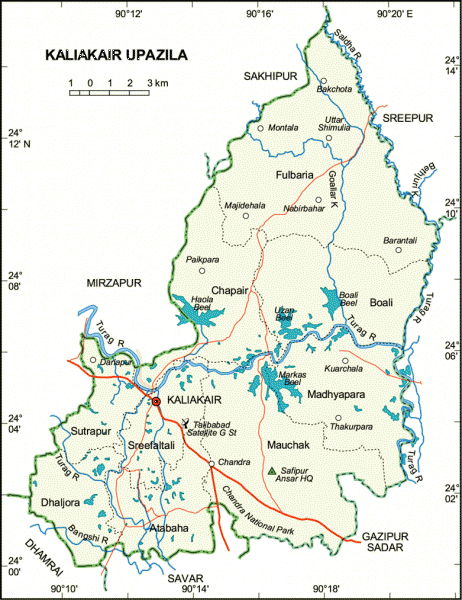
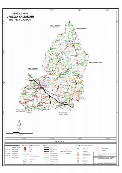
Kaliakair Upazila (Gazipur district) with an area of 314.14 sq km, is bounded by Mirzapur and Sakhipur upazilas on the north, Savar and Gazipur sadar upazilas on the south, Gazipur sadar and Sreepur upazilas on the east, Mirzapur and Dhamrai upazilas on the west. The Bangshi river is almost dead. Haola and Makash Beels are notable.
The geographic coordinates of Kaliakair town are 24.0671293N 90.2122194E degree. Kaliakair (Town) consists of 4 mouzas with an area of 5.37 sq km. It has a population of 10374; male 57.61%, female 42.39%; density of population is 1932 per sq km. Literacy rate among the town people is 51.2%. The town is gradually expanding centring round Talibabad Satellite Ground Centre, Bangladesh Adventist Seminary and College.
Kaliakair thana, now an upazila, was established in 1923. It consists of 9 union parishads, 181 mouzas and 283 villages.
Archaeological heritage A big tank and the remnants of a nearly extinct royal palace at village Dholsamudra.
Historical events During the time of Mughal Subadar Islam Khan, Talib Khan was deputed to this area as an administrator to review revenue collection. The place was named after him as Talibabad Pargana.
Religious institutions Mosque 309, temple 55, church 4.
As of 1991 Bangladesh census, Population 232915; male 51.21%, female 48.79%; Muslim 84.33%, Hindus 15.12%, Christian 0.41%, Buddhist 0.01%, others 0.13%; ethnic nationals: Koch-Bangshi 3000 (500 families).
Literacy rate and educational institutions Average literacy 28.45%, male 37.1%, female 19.8%. Educational institutions: college 4, secondary school 58, madrasa 15, government primary school 86, non-government primary school 24, kg school 15.
Main occupations Agriculture 50.12%, fishing 1.59%, agricultural labourer 15.56%, wage labourer 3.46%, commerce 8.93%, transport 1.82%, construction 1.01%, service 6.17%, others 11.34%.
Land use Total land under cultivation 15267 hectares, fallow land 7333 hectares, single crop land 67.04%, double crop 32.96%.
Land control Among the peasants 15% landless, 40% marginal peasants, 35% intermediate peasant, 10% rich.
Poultry, fishery and dairy Poultry 1750, fishery 500, dairy 20.
Communication facilities Roads: pucca 60 km, semi pucca 20 km, mud road 375 km; waterways 54 nautical mile.
Manufactories Aluminium factory 1, jute mill 1, paper mill 2, pharmaceutical 4, steel mill 2, oil mill 12, rice mill 75, sawmill 15.
Cottage industries Potteries 200, bamboo and cane work 25, jute product 12, nakshi kantha 5, jhinuk lime 3, chanachur work 15, bakery 10, ball pen industries 4, goldsmith 115, blacksmith 45, wood work 175, tailoring 525, welding 55.
NGO activities brac, proshika, grameen bank, asa, caritas, Samas, Prokas, Pallikalyan, Jibika, Satata.
Health centres Upazila health complex 1, health sub centres 4, family welfare centres 9.
Nearby cities:
স্থানাঙ্ক: 24°4'6"N 90°12'55"E
- কেরানিগঞ্জ উপজেলা 35 কিঃমিঃ
- কাপাসিয়া উপজেলা 35 কিঃমিঃ
- রূপগঞ্জ উপজেলা 36 কিঃমিঃ
- গফরগাঁও উপজেলা 58 কিঃমিঃ
- লোহাগঞ্জ উপজেলা 59 কিঃমিঃ
- মতলব উপজেলা 72 কিঃমিঃ
- ধোবাউড়া উপজেলা 126 কিঃমিঃ
- পটিয়া উপজেলা 250 কিঃমিঃ
- চন্দনাইশ উপজেলা 266 কিঃমিঃ
- বাঁশখালী উপজেলা 268 কিঃমিঃ
- কালিয়াকৈর ডিগ্রী কলেজ 1.6 কিঃমিঃ
- FAZAL HAQUE 10 কিঃমিঃ
- ঢাকা বিভাগ 15 কিঃমিঃ
- গাজীপুর জেলা 23 কিঃমিঃ