Brandywine Airport (OQN)
USA /
Pennsylvania /
West Goshen /
Ward Ave., 1205
World
/ USA
/ Pennsylvania
/ West Goshen
World / United States / Pennsylvania
airport, municipal
Airport Identifier: OQN
Elevation: 466 ft / 142.04 m (Surveyed)
Land: 44 acres
From nearest city: 3 nautical miles NE of West Chester
Location: Chester County, PA
Magnetic Variation: 12W (2000)
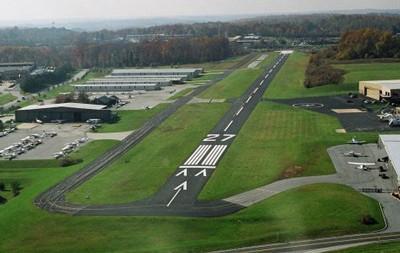
Brandywine Airport (IATA: OQN, ICAO: KOQN, FAA LID: OQN) is a public use airport located in West Goshen Township, Pennsylvania, three nautical miles (6 km) northeast of the central business district of West Chester. It is privately owned by the New Brandywine Airport Club Inc.Brandywine Airport covers an area of 44 acres (18 ha) at an elevation of 466 feet (142 m) above mean sea level. It has one runway designated 9/27 with an asphalt surface measuring 3,347 by 50 feet (1,020 x 15 m).
1205 Ward Ave., West Chester, PA 19380
+1 610 692-6100 voice
+1 610 692-6213 fax
koqn.net/
www.airport-data.com/airport/OQN/
www.globalair.com/airport/airport.aspx?aptcode=KOQN
Elevation: 466 ft / 142.04 m (Surveyed)
Land: 44 acres
From nearest city: 3 nautical miles NE of West Chester
Location: Chester County, PA
Magnetic Variation: 12W (2000)
Brandywine Airport (IATA: OQN, ICAO: KOQN, FAA LID: OQN) is a public use airport located in West Goshen Township, Pennsylvania, three nautical miles (6 km) northeast of the central business district of West Chester. It is privately owned by the New Brandywine Airport Club Inc.Brandywine Airport covers an area of 44 acres (18 ha) at an elevation of 466 feet (142 m) above mean sea level. It has one runway designated 9/27 with an asphalt surface measuring 3,347 by 50 feet (1,020 x 15 m).
1205 Ward Ave., West Chester, PA 19380
+1 610 692-6100 voice
+1 610 692-6213 fax
koqn.net/
www.airport-data.com/airport/OQN/
www.globalair.com/airport/airport.aspx?aptcode=KOQN
Wikipedia article: http://en.wikipedia.org/wiki/Brandywine_Airport
Nearby cities:
Coordinates: 39°59'27"N 75°34'54"W
- Philadelphia International Airport (PHL/KPHL) 28 km
- New Castle Airport (KILG/ILG) 33 km
- Lehigh Valley International Airport (ABE/KABE) 75 km
- McGuire Air Force Base (WRI/KWRI) 83 km
- Dover Air Force Base (KDOV/DOV) 94 km
- Atlantic City International Airport 102 km
- Morristown Municipal Airport (MMU) 134 km
- Newark Liberty International Airport (EWR/KEWR) 142 km
- Floyd Bennett Field (NOP) 158 km
- John F. Kennedy International Airport (JFK/KJFK) 167 km
- West Chester East High School & J R Fugett Middle School 1.8 km
- West Goshen, Pennsylvania 2.7 km
- Immaculata University 4.2 km
- Applebrook Golf Club 4.4 km
- Chester Valley Golf Club 5.9 km
- Malvern Prep 7.2 km
- Malvern, Pennsylvania 7.5 km
- Paoli, Pennsylvania 10 km
- Delaware County, Pennsylvania 16 km
- Montgomery County, Pennsylvania 31 km