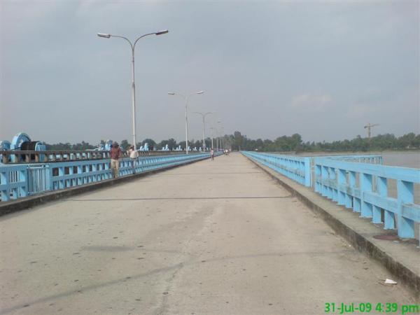
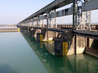
Teesta bridge / barrage
India /
Bangla /
Mathabhanga /
Lalmonirhat, Bangladesh
World
/ India
/ Bangla
/ Mathabhanga
Munno / Bangladesh / / /
Dammen, barrage (en), bru
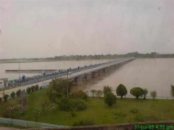
(((((((Teesta barrage upon the teesta river under hatibanda upazila in lalmonirhut district.It is made for irrigation project in north bengal area in bangladesh..................by milon 01817575003.....)))))))))
Background
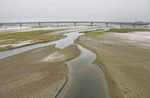
A vast area of North-Bangladesh suffers from scarcity of water for irrigating its agricultural lands, not only in dry months but also during monsoon when a prolonged spell of scarcity/no rainfall affects crops. The idea of irrigation from the Teesta River was conceived since Britsh time (1945).
In our territory, the preliminary feasibility report of the project was prepared in 1960 by M/s. Haigh Zinn and Associates in collaboration with A.C.E. Ltd. (Pakistan) and the second one was prepared by M/s. B innie and Partners Ltd. during 1968-70.
Under the changed circumstances Engineers of BWDB and BUET reviewed the previous reports and conducted fresh survey, investigation, planning and detailed Engineering. The site of the Barrage was selected at Doani where the present Teesta Barrage proudly stands today.
Boundary and Area
The project is bounded by the Teesta on the North, the Atrai on the West, Shantahar-Bogra Railway line on the South and Bogra-Kaunia Railway line on the East.
Command Area : 750,000 ha.
Irrigable Area : 540,000 ha.
Objective
The main objective of the project is to increase agricultural production through supplementary irrigation and thereby create employment opportunities.
Phasing and Costing
Although the the implementation of the project started in 1960, the actual construction of the Barrage was taken up in 1979 and that of canal system in 1984-85.
To derive early benefits, the Project has been phased out viz. Phase-1 and Phase-11. The Phase-1 (restructured) has a command area of 154,250 hectares with a net irrigable area of 111,406 hectares. It is spreaded over 12 (twelve) Upaziila namely: Nilphamari, Dimla, Jaldhaka, Kishoreganj, Saidpur, Rangpur, Taraganj, Badarganj, Gangachara, Parbatipur, Chirir-bandar & Khanshama. It comprises construction of a Barrage, Flood Embankment, Flood By Pass, Silt Trap, Main Canal and part of canal system with improvement of existing drainage canal.
GOB'S own resources were financing the project since inception. In 1985 and 1994 GOB entered into three loan agreements with SFD, IDB and AFD for partial financing of the project. After phasing out of the project, the Phase-1 was completed in June, 1998 and the cost incurred is Tk. 9695.29 million including the price of 27,000 m.tons of wheat (the cost includes Tk. 1,850.00 million from above donors).
Agricultural Development
Irrigation had started from January, 1993 in the upper reach where canals were ready with cross drainage structures in place and on an average 6,500 ha. were irrigated in 1st and 2nd Kharif since 1993. Last year (in Kharif-11 of 2001) irrigation coverage was 57,626 ha. Full coverage of 111,406 ha. could be achieved by 2003.
Command Area Development
The project was completed in June, 1998. The irrigation network as constructed need to be evaluated as an integrated way to identify the bottlenecks of the system to bring the potential irrigable area under irrigation. On the other hand, the design drainage area of the drainage structures might have been changed with the new interventions; it requires whole review of the drainage system. As such a Command Area Development (CAD) Project for Phase-1 was introduced in 199899 for five years. The project cost is Tk. 967.96 million.
The objectives of the Project is to accelerate agricultural production upto full potential by irrigation coverage and integrated water management as well as socio-economic enhancement by introducing multiple development program viz. fisheries, duck culture, grass cultivation, afforestation etc. The following government organizations are involved to attain the objectives:
Bangladesh Water Development Board (BWDB).
Directorate of Agriculture Extension (DAE).
Directorate of Fishery.
Directorate of Livestock.
Directorate of Forestry.
Benefits
a) Agriculture:
The project needs about Tk. 290 million for operation and maintenance_ of the project in each fiscal year. To meet up the expenses of 0 & M a part of the 0 & M budget has been levied from the beneficiaries
as water charge through registered water users group (WUG) but the collection from the beneficiaries is not remarkable.
b) Women in Development:
In our rural economy & social system women play a vital role in collecting and processing of crops. In fact landless widows and distressed women will have increased job opportunities.
c) Communication:
On both sides of the 649.00 km. irrigation canals, there will be 1298.00 km. dykes serving as all weather village roads and improve communication of the remote areas. Besides about 100 km. of metaled road provide better communication facilities in the area.
d) Fishery and Poultry:
Nearly 150 km. Main and Secondary Canals, 600 km. of major drainage channels and Silt Trap reservoir will create a watershed of about 50 sq. km. which provide ample opportunities for pisciculture and duck farming.
e) Plantation:
Plantation of about 0.70 million trees will be done on both sides of the canal dykes and structure sites of which 0.10 million have been accomplished.
f) Environment:
Watershed of the reservoir and canals, green crops and the trees along the dykes would bring in positive impact on the climate. A vast land in the northern region of the country hitherto suffering from desertification will be transformed into crop land and thus bring in green revolution. The flora and fauna will advent. On the whole, the socio-economic condition would change immensely and would usher in a better living condition of the people.
g) Recreation and Tourism:
In this region, the whole of the country has little space free for recreation. Around the gigantic, magnificent beautiful Barrage and its head works there are green parks, flower gardens, lagoons in old course of the Teesta and the Silt Trap. The migratory birds from the nearby Himalayas make a natural sanctuary in the reservoir in front of the Barrage. From here the snowcapped Kanchanjhanga is visible in Autumn. Many visitors and tourists pour to this beautiful spot every day, particularly in winter to enjoy the beauty of nature.
Salient Features of the Project:
S1.No.
Items
Whole Proiect
Phase-1
1
Benefitted Area.
750,000 ha.
154,250 ha.
2
Irrigable Area
540,000 ha.
111,406 ha.
3
Barrage (615 m.)
1 no.
1 no.
4
Canal Head Regulator (110 m.)
1 no.
1 no.
5
Closure Dam (2,470 m.)
1 no.
1 no.
6
Flood By-Pass (610 m.)
1 no.
1 no.
7
Silt Trap
1 no.
1 no.
8
Flood Embankment
80 km.
80 km.+Bank prot. (1 Item)
8
Main Canal
34 km.
33.67 km.
9
Major Secondary Canal
(Rangpur, Bogra & Dinajpur)
275 km.
74.85 km.
10
Secondary Canal
1,450 km.
215.24 km.
11
Tertiary Canal
2,720 km.
325.24 km.
12
Drainage Channel
5,000 km.
250.00 km.
13
Irrigation Structures
1,512 nos.
1,110 nos.
14
Drainage Structure
2,320 nos.
50 nos.
16
Turn Out
15,000 nos.
2,000 nos.
17
Inspection Road
33.67 km.
100 km.
Background
A vast area of North-Bangladesh suffers from scarcity of water for irrigating its agricultural lands, not only in dry months but also during monsoon when a prolonged spell of scarcity/no rainfall affects crops. The idea of irrigation from the Teesta River was conceived since Britsh time (1945).
In our territory, the preliminary feasibility report of the project was prepared in 1960 by M/s. Haigh Zinn and Associates in collaboration with A.C.E. Ltd. (Pakistan) and the second one was prepared by M/s. B innie and Partners Ltd. during 1968-70.
Under the changed circumstances Engineers of BWDB and BUET reviewed the previous reports and conducted fresh survey, investigation, planning and detailed Engineering. The site of the Barrage was selected at Doani where the present Teesta Barrage proudly stands today.
Boundary and Area
The project is bounded by the Teesta on the North, the Atrai on the West, Shantahar-Bogra Railway line on the South and Bogra-Kaunia Railway line on the East.
Command Area : 750,000 ha.
Irrigable Area : 540,000 ha.
Objective
The main objective of the project is to increase agricultural production through supplementary irrigation and thereby create employment opportunities.
Phasing and Costing
Although the the implementation of the project started in 1960, the actual construction of the Barrage was taken up in 1979 and that of canal system in 1984-85.
To derive early benefits, the Project has been phased out viz. Phase-1 and Phase-11. The Phase-1 (restructured) has a command area of 154,250 hectares with a net irrigable area of 111,406 hectares. It is spreaded over 12 (twelve) Upaziila namely: Nilphamari, Dimla, Jaldhaka, Kishoreganj, Saidpur, Rangpur, Taraganj, Badarganj, Gangachara, Parbatipur, Chirir-bandar & Khanshama. It comprises construction of a Barrage, Flood Embankment, Flood By Pass, Silt Trap, Main Canal and part of canal system with improvement of existing drainage canal.
GOB'S own resources were financing the project since inception. In 1985 and 1994 GOB entered into three loan agreements with SFD, IDB and AFD for partial financing of the project. After phasing out of the project, the Phase-1 was completed in June, 1998 and the cost incurred is Tk. 9695.29 million including the price of 27,000 m.tons of wheat (the cost includes Tk. 1,850.00 million from above donors).
Agricultural Development
Irrigation had started from January, 1993 in the upper reach where canals were ready with cross drainage structures in place and on an average 6,500 ha. were irrigated in 1st and 2nd Kharif since 1993. Last year (in Kharif-11 of 2001) irrigation coverage was 57,626 ha. Full coverage of 111,406 ha. could be achieved by 2003.
Command Area Development
The project was completed in June, 1998. The irrigation network as constructed need to be evaluated as an integrated way to identify the bottlenecks of the system to bring the potential irrigable area under irrigation. On the other hand, the design drainage area of the drainage structures might have been changed with the new interventions; it requires whole review of the drainage system. As such a Command Area Development (CAD) Project for Phase-1 was introduced in 199899 for five years. The project cost is Tk. 967.96 million.
The objectives of the Project is to accelerate agricultural production upto full potential by irrigation coverage and integrated water management as well as socio-economic enhancement by introducing multiple development program viz. fisheries, duck culture, grass cultivation, afforestation etc. The following government organizations are involved to attain the objectives:
Bangladesh Water Development Board (BWDB).
Directorate of Agriculture Extension (DAE).
Directorate of Fishery.
Directorate of Livestock.
Directorate of Forestry.
Benefits
a) Agriculture:
The project needs about Tk. 290 million for operation and maintenance_ of the project in each fiscal year. To meet up the expenses of 0 & M a part of the 0 & M budget has been levied from the beneficiaries
as water charge through registered water users group (WUG) but the collection from the beneficiaries is not remarkable.
b) Women in Development:
In our rural economy & social system women play a vital role in collecting and processing of crops. In fact landless widows and distressed women will have increased job opportunities.
c) Communication:
On both sides of the 649.00 km. irrigation canals, there will be 1298.00 km. dykes serving as all weather village roads and improve communication of the remote areas. Besides about 100 km. of metaled road provide better communication facilities in the area.
d) Fishery and Poultry:
Nearly 150 km. Main and Secondary Canals, 600 km. of major drainage channels and Silt Trap reservoir will create a watershed of about 50 sq. km. which provide ample opportunities for pisciculture and duck farming.
e) Plantation:
Plantation of about 0.70 million trees will be done on both sides of the canal dykes and structure sites of which 0.10 million have been accomplished.
f) Environment:
Watershed of the reservoir and canals, green crops and the trees along the dykes would bring in positive impact on the climate. A vast land in the northern region of the country hitherto suffering from desertification will be transformed into crop land and thus bring in green revolution. The flora and fauna will advent. On the whole, the socio-economic condition would change immensely and would usher in a better living condition of the people.
g) Recreation and Tourism:
In this region, the whole of the country has little space free for recreation. Around the gigantic, magnificent beautiful Barrage and its head works there are green parks, flower gardens, lagoons in old course of the Teesta and the Silt Trap. The migratory birds from the nearby Himalayas make a natural sanctuary in the reservoir in front of the Barrage. From here the snowcapped Kanchanjhanga is visible in Autumn. Many visitors and tourists pour to this beautiful spot every day, particularly in winter to enjoy the beauty of nature.
Salient Features of the Project:
S1.No.
Items
Whole Proiect
Phase-1
1
Benefitted Area.
750,000 ha.
154,250 ha.
2
Irrigable Area
540,000 ha.
111,406 ha.
3
Barrage (615 m.)
1 no.
1 no.
4
Canal Head Regulator (110 m.)
1 no.
1 no.
5
Closure Dam (2,470 m.)
1 no.
1 no.
6
Flood By-Pass (610 m.)
1 no.
1 no.
7
Silt Trap
1 no.
1 no.
8
Flood Embankment
80 km.
80 km.+Bank prot. (1 Item)
8
Main Canal
34 km.
33.67 km.
9
Major Secondary Canal
(Rangpur, Bogra & Dinajpur)
275 km.
74.85 km.
10
Secondary Canal
1,450 km.
215.24 km.
11
Tertiary Canal
2,720 km.
325.24 km.
12
Drainage Channel
5,000 km.
250.00 km.
13
Irrigation Structures
1,512 nos.
1,110 nos.
14
Drainage Structure
2,320 nos.
50 nos.
16
Turn Out
15,000 nos.
2,000 nos.
17
Inspection Road
33.67 km.
100 km.
Nearby cities:
Koordinater: 26°10'42"N 89°3'6"E