Fall River Government Center (Fall River, Massachusetts)
USA /
Massachusetts /
Somerset /
Fall River, Massachusetts /
Government Center, 1
World
/ USA
/ Massachusetts
/ Somerset
World / United States / Rhode Island
city hall
Add category
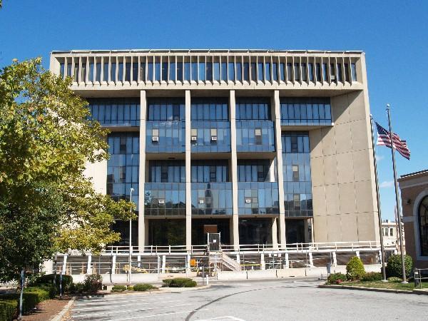
City Hall for the city of Fall River. Dedicated in 1976; built as part of a 12-year project to replace the previous city hall, which dated from the 1840s and had survived the 1928 fire, as part of the project for building Interstate 195. One of the only municipal buildings in the world constructed over a highway, as well as over the Quequechan River, which originally flowed through the northern half of the building's site before being put underground to supply the neighboring mills.
1 Government Center
Fall River, MA
(508) 324-2000
www.fallriverma.org
1 Government Center
Fall River, MA
(508) 324-2000
www.fallriverma.org
Nearby cities:
Coordinates: 41°42'3"N 71°9'16"W
- City Hall 14 km
- Rehoboth Town Hall and Parks 21 km
- Prophet Circle Drive. 124 km
- West Hartford Town Hall 132 km
- Burlington Town Hall 150 km
- Green Mountain Power 188 km
- Stansish Town Offices 233 km
- Grafton County Offices 279 km
- Town Hall 305 km
- Wilton Town Hall 331 km
- Brayton Point Power Station (Closed) 3.4 km
- North Watuppa Pond 4 km
- Somerset, Massachusetts 4.7 km
- South Watuppa Pond 5.3 km
- Fall River Industrial Park 6.5 km
- Tiverton, Rhode Island 7 km
- Swansea, Massachusetts 8.8 km
- Copicut Resivoir 10 km
- Freetown, Massachusetts 14 km
- Newport County, Rhode Island 18 km