Kueishan/Turtle Island
Taiwan /
Ilan /
Toucheng /
World
/ Taiwan
/ Ilan
/ Toucheng
World / Republic of China / Taiwan
island
Add category

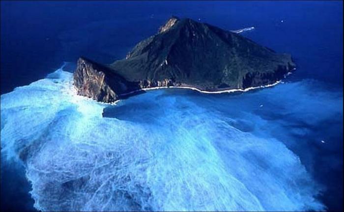

Also known as Guishan Island. Locals call it Turtle Mountian Island due to it's shape and profile from certain points on the coast of Taiwan. Actually a stratovolcano with an estimated last eruption occuring around 1795. The island is made up of andesitic lava flows and volcaniclastic material. Kueishantao displays vigorous active submarine fumaroles and solfataras that discolor seawater over wide areas. It is a landmark in I-Lan County.
160.111.247.173/world/volcano.cfm?vnum=0801-031
160.111.247.173/world/volcano.cfm?vnum=0801-031
Wikipedia article: http://en.wikipedia.org/wiki/Guishan_Island_(Yilan)
Nearby cities:
Coordinates: 24°50'34"N 121°56'58"E
- Yonaguni island 108 km
- Senkaku Islands 194 km
- Penghu 280 km
- Langqi Island 282 km
- Jiangyin Island 283 km
- Meizhu Island 290 km
- Sandu Island 308 km
- Orchid Island 310 km
- Kinmen 373 km
- Xiamen 394 km
- Kueinshantao Volcano 0.3 km
- National Center for Traditional Arts 22 km
- Chinese Cemetery 22 km
- Wujie 23 km
- Fo Guang University 23 km
- Chinese Cemetery 24 km
- Ilan South Airport (disused) 24 km
- 901 金六結 24 km
- Luodong Township 25 km
- Meihua Lake 31 km