Andravida Air Base
| military airbase, map location with missing/unclear/blurred data
Greece /
Ilia /
Lekhaina /
World
/ Greece
/ Ilia
/ Lekhaina
, 2 km from center (Λεχαινά)
World / Greece / Dytiki Ellada
military airbase, map location with missing/unclear/blurred data
Andravida Air Base (Greek: Αεροπορική Βάση Ανδραβίδας) is a military airport operated by the Hellenic Air Force, located 2.5 kilometres from the town of Andravida in Elis, Greece, housing the 117th Combat Wing (117 Πτέρυγα Μάχης, 117 ΠΜ), and the Air Force's Air Tactics Center (Κέντρο Αεροπορικής Τακτικής, ΚΕΑΤ).
Airport type: Military
Elevation: 55 ft / 17 m
Runway 16/34; lenght: 10.299 feet (3.139 m); Asphalt
117th Combat Wing:
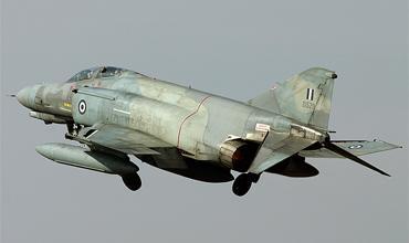
- 338th Fighter Bomber Squadron "ARES (Mars)" (F-4E Phantom II)
Airport type: Military
Elevation: 55 ft / 17 m
Runway 16/34; lenght: 10.299 feet (3.139 m); Asphalt
117th Combat Wing:
- 338th Fighter Bomber Squadron "ARES (Mars)" (F-4E Phantom II)
Wikipedia article: http://en.wikipedia.org/wiki/Andravida_Air_Base
Nearby cities:
Coordinates: 37°55'16"N 21°17'24"E
- Al Khadim Air Base 652 km
- Uthman Airbase 1003 km
- al-Watya Air Base 1048 km
- Sphinx International Airport 1236 km
- Sdot Micha Airbase 1412 km
- Ovda IAF Airbase & International Airport 1534 km
- Ain al-Asad/al-Qadissiyyah Airfield 1953 km
- Wadi Al Khirr Airbase 2116 km
- Al salman military airport (disused) 2275 km
- King Khalid Air Base 3016 km
- Runway 16/34 0.2 km
- Shelters 1 km
- Lechena Solar Field 3.2 km
- Olympia Radio 7.9 km
- Ancient Elis Archaeological site 8.2 km
- "Kotyhi" lagoon 10 km
- Pineiou lake 17 km
- National Park Kotychi-Kalogrias-Araxos 20 km
- Peripheral unit of Ilia 31 km
- Peripheral unit of Achaea 53 km