Medieval necropolis with stećak of Knyaz Radoje Radosalić-Pribinić
| cemetery, place with historical importance, Medieval / Middle Ages
Bosnia and Herzegovina /
Federacija Bosna i Hercegovina /
Polje /
World
/ Bosnia and Herzegovina
/ Federacija Bosna i Hercegovina
/ Polje
cemetery, place with historical importance, Medieval / Middle Ages
Medieval necropolis with stećak of Radoje Radosalić-Pribinić, Grand Knyaz of Bosnia.
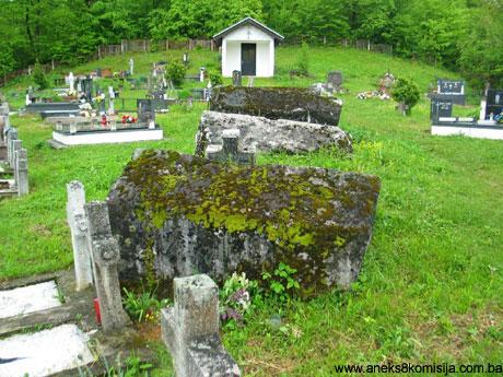
The historic site of the mediaeval necropolis between the villages of Zabrđe and Toplica, Municipality Kiseljak, designated as a National Monument of Bosnia and Herzegovina.
About forty years ago, there were 17 stećak tombstones in the cemetery. There are now 14 intact and one broken and moved from its original position. There is an area in the cemetery, close to the stećaks, of irregular ground overgrown with vegetation, beneath which there are certainly another one or more stećaks.
According to the records of the Republic Institute for the Protection of Cultural Monuments, there were a further 16 stećaks outside the cemetery around the road to Toplica; these had already disappeared by the late 1950s (Anđelić, 1963, 182).
The village of Zabrđe is in the upper course of the river Lepenica, in the southern part of the area now known as Lepenica, which covers the course of the river from Kiseljak in the north to the confluence of Crna Rijeka and Bioča, which then become the river Lepenica. The village itself is in the valley by the river, with Brdanjak hill above. It is on Brdnjak, which is between the villages of Zabrđe and Toplica, that the necropolis of stećak tombstones stands, in a Roman Catholic cemetery that is still in use. There is a Muslim cemetery very close to the Catholic one.
Below, in the village of Zabrđe, there was a Muslim cemetery in which there were two stećak tombstones.
Stećak of Radoje Radosalić-Probinić, Grand Knyaz of Bosnia - group of stećaks:
1. Ridge-shaped tombstone with plinth. Size: sarcophagus: 1.8 x 1.30 x 1.2 x 1m; of which the height of the ridge is 0.2 m. Plinth: 2.2 x 1.70 x 02 m.
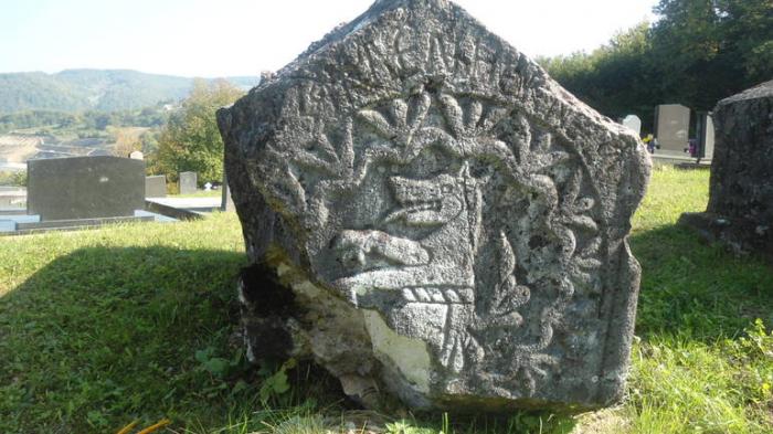
2. Ridge-shaped tombstone with plinth. Size: sarcophagus: 2 x 1.10 x 1.2 m; of which the height of the ridge is 0.3 m. Plinth: 2.4 x 1.45 x 02 m. All the angles of the sarcophagus are decorated with twisted bands executed in relief. There is an eight-pointed rosette on the roof surface of the stećak; this rosette design is an integral part of the heraldic composition on the seal with the Pribinić coat of arms found in the tomb of King Tvrtko I in Mile (Anđelić, 1979, 223). The coat of arms on the west, front face, and the epitaph on the south, side face. Part of the epitaph, consisting of the first three words (SE ZALMENIJE KNEZA), is above the coat of arms. The coat of arms itself is set in a wavy band with three leaves growing from the hollow of each wave. A carving of the upper part of the body and head of a wolf, facing to the left, features in a circle; the mouth of the wolf is open showing the lower teeth and long lolling tongue. The powerful front legs are extended. Beneath the body is a torse or wreath in the form of a twisted band, with below this part of a helmet or shield with mantle, the tassled end of which is turned upwards (Anđelić, 1959., 181; idem, 1979, 223; Bešlagić, 1967, 42-43).
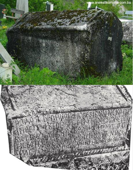
The epitaph is in Bosnian Cyrillic. It begins in a semi-circle above the coat of arms on the west face and continues on the south side face. As a whole, it reads: “[S]E ZALMENIJE KNEZA RADOJA, VELIKOG KNEZA BOSANSKOG, A POSTAVI JEGA SIN NJEGOV KNEZ RADIČ Z BOŽJOM POMOĆU i SVOJIH VJERNIH A S INOM NIJEDNOM POMOĆU NEGO SAM ON” (In memory of Prince Radoje, Grand Prince of Bosnia, erected by his son Prince Radič with the help of God and his loyal followers and there is no help but him) (Vego 1970, 64-65, no. 251; Anđelić, 1984, 121). Three eight-pointed rosettes are incised between the words in the second line of the epitaph.
The dating of the stećak was carried out according to the last charter in which Grand Prince of Bosnia Radoje Radosalić appears as a witness, dating from 1408, and charters dating from 1408 and 1417 in which his son, Prince Radić, appears as a witness. The stećak would thus have been erected between 1408 and 1417 (Anđelić, 1984, 144).
old.kons.gov.ba/main.php?id_struct=6&lang=4&act...
The historic site of the mediaeval necropolis between the villages of Zabrđe and Toplica, Municipality Kiseljak, designated as a National Monument of Bosnia and Herzegovina.
About forty years ago, there were 17 stećak tombstones in the cemetery. There are now 14 intact and one broken and moved from its original position. There is an area in the cemetery, close to the stećaks, of irregular ground overgrown with vegetation, beneath which there are certainly another one or more stećaks.
According to the records of the Republic Institute for the Protection of Cultural Monuments, there were a further 16 stećaks outside the cemetery around the road to Toplica; these had already disappeared by the late 1950s (Anđelić, 1963, 182).
The village of Zabrđe is in the upper course of the river Lepenica, in the southern part of the area now known as Lepenica, which covers the course of the river from Kiseljak in the north to the confluence of Crna Rijeka and Bioča, which then become the river Lepenica. The village itself is in the valley by the river, with Brdanjak hill above. It is on Brdnjak, which is between the villages of Zabrđe and Toplica, that the necropolis of stećak tombstones stands, in a Roman Catholic cemetery that is still in use. There is a Muslim cemetery very close to the Catholic one.
Below, in the village of Zabrđe, there was a Muslim cemetery in which there were two stećak tombstones.
Stećak of Radoje Radosalić-Probinić, Grand Knyaz of Bosnia - group of stećaks:
1. Ridge-shaped tombstone with plinth. Size: sarcophagus: 1.8 x 1.30 x 1.2 x 1m; of which the height of the ridge is 0.2 m. Plinth: 2.2 x 1.70 x 02 m.
2. Ridge-shaped tombstone with plinth. Size: sarcophagus: 2 x 1.10 x 1.2 m; of which the height of the ridge is 0.3 m. Plinth: 2.4 x 1.45 x 02 m. All the angles of the sarcophagus are decorated with twisted bands executed in relief. There is an eight-pointed rosette on the roof surface of the stećak; this rosette design is an integral part of the heraldic composition on the seal with the Pribinić coat of arms found in the tomb of King Tvrtko I in Mile (Anđelić, 1979, 223). The coat of arms on the west, front face, and the epitaph on the south, side face. Part of the epitaph, consisting of the first three words (SE ZALMENIJE KNEZA), is above the coat of arms. The coat of arms itself is set in a wavy band with three leaves growing from the hollow of each wave. A carving of the upper part of the body and head of a wolf, facing to the left, features in a circle; the mouth of the wolf is open showing the lower teeth and long lolling tongue. The powerful front legs are extended. Beneath the body is a torse or wreath in the form of a twisted band, with below this part of a helmet or shield with mantle, the tassled end of which is turned upwards (Anđelić, 1959., 181; idem, 1979, 223; Bešlagić, 1967, 42-43).
The epitaph is in Bosnian Cyrillic. It begins in a semi-circle above the coat of arms on the west face and continues on the south side face. As a whole, it reads: “[S]E ZALMENIJE KNEZA RADOJA, VELIKOG KNEZA BOSANSKOG, A POSTAVI JEGA SIN NJEGOV KNEZ RADIČ Z BOŽJOM POMOĆU i SVOJIH VJERNIH A S INOM NIJEDNOM POMOĆU NEGO SAM ON” (In memory of Prince Radoje, Grand Prince of Bosnia, erected by his son Prince Radič with the help of God and his loyal followers and there is no help but him) (Vego 1970, 64-65, no. 251; Anđelić, 1984, 121). Three eight-pointed rosettes are incised between the words in the second line of the epitaph.
The dating of the stećak was carried out according to the last charter in which Grand Prince of Bosnia Radoje Radosalić appears as a witness, dating from 1408, and charters dating from 1408 and 1417 in which his son, Prince Radić, appears as a witness. The stećak would thus have been erected between 1408 and 1417 (Anđelić, 1984, 144).
old.kons.gov.ba/main.php?id_struct=6&lang=4&act...
Wikipedia article: https://sh.wikipedia.org/wiki/Pribinići
Nearby cities:
Coordinates: 43°50'6"N 18°6'37"E
- Blace Necropolis 24 km
- Islamic cemetery 40 km
- HAREM - MUSLIM CEMETERY 56 km
- Cemetery 56 km
- Partizan cemetery 60 km
- Serbian Orthodox Cemetery 60 km
- Catholic Cemetery 85 km
- Prebilovci 87 km
- Muslim cemetery 88 km
- Cemetery 106 km
- luke 3.3 km
- Osenik 3.9 km
- Vojni Poligoni COO Pazarić 7.5 km
- Garovci 7.6 km
- Hadzici 7.9 km
- Kasatici 8.4 km
- Igman Ski - MALO POLJE 13 km
- Igman mountain 14 km
- Bjelašnica 20 km
- Trnovo (FB&H) 30 km