Antikythera
Greece /
Hania /
Platanos /
World
/ Greece
/ Hania
/ Platanos
, 52 km from center (Πλάτανος)
World / Greece / Attiki
island
Add category

en.wikipedia.org/wiki/Antikythera_mechanism
www.antikythera.gr/en/
Antikythera or Anticythera (/ˌæntɪkɪˈθɪərə/, /ˌæntɪsɪˈθɪərə/; Ancient Greek: Ἀντικύθηρα Greek: Αντικύθηρα, Greek pronunciation: [andiˈciθira], literally "opposite Kythera") is a Greek island lying on the edge of the Aegean Sea, between Crete and Peloponnese. Since the 2011 local government reform it is part of the municipality of Kythera island. Antikythera may also refer to the Antikythera Strait, through which modified Mediterranean water enters the Sea of Crete.Its land area is 20.43 square kilometres (7.89 square miles), and it lies 38 kilometres (24 miles) south-east of Kythira. It is the most distant part of the Attica region from its heart in the Athens metropolitan area. It is lozenge-shaped, 10.5 km (6.5 mi) NNW to SSE by 3.4 km (2.1 mi) ENE to WSW. It is notable for being the location of the discovery of the Antikythera mechanism and for the historical Antikythera wreck.
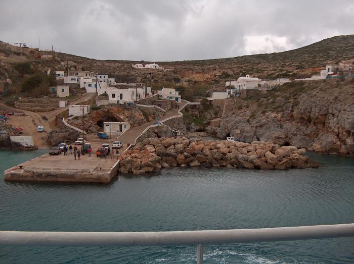
Its main settlement and port is Potamós (pop. 34 inhabitants in the 2011 census). The only other settlements are Galanianá (pop. 15), and Charchalianá (pop. 19). Antikythera is periodically visited by the Ablemon Nautical Company ferry F/B Ionis on its route between Piraeus (Athens) and Kissamos-Kastelli on Crete.
www.antikythera.gr/en/
Antikythera or Anticythera (/ˌæntɪkɪˈθɪərə/, /ˌæntɪsɪˈθɪərə/; Ancient Greek: Ἀντικύθηρα Greek: Αντικύθηρα, Greek pronunciation: [andiˈciθira], literally "opposite Kythera") is a Greek island lying on the edge of the Aegean Sea, between Crete and Peloponnese. Since the 2011 local government reform it is part of the municipality of Kythera island. Antikythera may also refer to the Antikythera Strait, through which modified Mediterranean water enters the Sea of Crete.Its land area is 20.43 square kilometres (7.89 square miles), and it lies 38 kilometres (24 miles) south-east of Kythira. It is the most distant part of the Attica region from its heart in the Athens metropolitan area. It is lozenge-shaped, 10.5 km (6.5 mi) NNW to SSE by 3.4 km (2.1 mi) ENE to WSW. It is notable for being the location of the discovery of the Antikythera mechanism and for the historical Antikythera wreck.
Its main settlement and port is Potamós (pop. 34 inhabitants in the 2011 census). The only other settlements are Galanianá (pop. 15), and Charchalianá (pop. 19). Antikythera is periodically visited by the Ablemon Nautical Company ferry F/B Ionis on its route between Piraeus (Athens) and Kissamos-Kastelli on Crete.
Wikipedia article: http://en.wikipedia.org/wiki/Antikythera
Nearby cities:
Coordinates: 35°51'51"N 23°17'56"E
- Photovoltaic power station 0.6 km
- Galaniana 1 km
- Charchaliana 1.2 km
- Castle 2.5 km
- Potamos Bay 2.6 km
- Antikythera shipwreck 2.9 km
- Akra Apolytarais Lighthouse 5.1 km
- Naftilos rocks 11 km