Ustyurt Nature Reserve
Kazakhstan /
Mankistau /
Tenga /
World
/ Kazakhstan
/ Mankistau
/ Tenga
nature conservation park / area
Add category
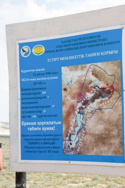


Ustyurt Nature Reserve (Kazakh: Үстірт мемлекеттік табиғи қорығы, Üstırt memlekettık tabiği qoryğy; Russian: Устюрт национальный заповедник, Ustyurt natsional'nyy zapovednik), or the Ustyurt National Biosphere Reserve, is a nature reserve, created on 12 July 1984 in what was then the Kazakh Soviet Socialist Republic (K.S.S.R.), in Mangystau Region, southwest Kazakhstan. Its area is 223,000 hectares (2,230 km2), and lies within Ustyurt Plateau. The reserve lies near the borders with Uzbekistan and Turkmenistan. Its purpose is to preserve the deserts as well as the rare flora and fauna. The Sherkala mountain and the Valley of Balls lie within the reserve. In addition, it contains a big variety of flora and fauna.
The temperatures vary greatly: from more than 40 °C (104 °F) during the summer months, down to less than −41 °C (−42 °F) during the winter months. The average annual precipitation is only 120 mm (4.7 in).
Ustyurt Nature Reserve contains a big variety of landscapes, from steppes and depressions to pillars reaching several hundred metres in height. The pillars can be several colours, including pale pink, blue and dazzling white. The vast Kenderlisor depression spans the entire length of the reserve, from the southwest to the northeast. Shakhr-i-Vazir, an ancient city, also lies in the reserve, along with dozens of Neolithic sites.
Wikipedia article: http://en.wikipedia.org/wiki/Ustyurt_Nature_Reserve
Nearby cities:
Coordinates: 42°47'9"N 54°18'36"E
- Astrakhan Natural Reserve 613 km
- Vashlovani National Park 684 km
- Bashkirsky strict nature reserve 1219 km
- Naurzum Nature Reserve 1239 km
- Samarskaya Luka National Park 1246 km
- South-Ural strict nature reserve 1333 km
- Nature park Iremel 1357 km
- National park Zuratkul 1396 km
- Ilmensky zapovednik 1459 km
- National park Taganay 1473 km
- Ruins 51 km
- Bolashak Border Guard Post 73 km
- Railway border station Bolashak-Export 73 km
- Possible Border Outpost 90 km
- Depression Assake Audan 188 km
- Possible Border Outpost 189 km
- Chink Kaplankyr 204 km
- Kumesebšek Key 215 km
- Kazahlışor 220 km
- Sands of Kumesebshen 234 km