Shur River ( Rud-e Shur River) - lut desert
Iran /
Kerman /
Ravar /
World
/ Iran
/ Kerman
/ Ravar
, 105 km from center (راور)
UNESCO World Heritage Site
Add category

VİDEO :
www.youtube.com/watch?v=G-477Qlkf_E
unesco :
whc.unesco.org/en/list/1505/gallery/
foto :
www.google.com.tr/search?q=%D8%B1%D9%88%D8%AF+%D8%B4%D9...
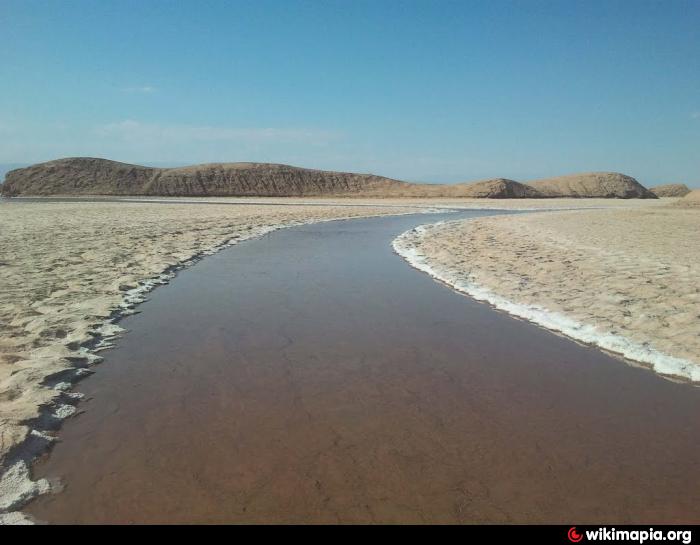
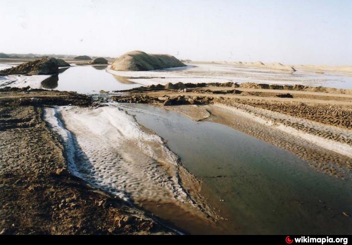
Rud-e Shur River to arrive at the mine creates salt mountain. River water, the saltiest and most mineral waters in the world within. At the time of high water is salty and briny lake forms at the time of dehydration due to settling of white salt desert, sand draws on the beauty effects. Although the near Kalut Kalut damp walls, on the strength of the natural erosion of the buildings had a positive effect LIFE Clute Hara guarantees. The water level so high that no plant growing on the shores of it does not. This is due to the depth of Tbkhyrkmtr less water and place the dough in the middle of the desert is ultimately converted into beautiful crystals of salt.
www.irandeserts.com/content/%D8%AF%D8%B1%DA%AF%D8%A7%D9...
This river that originates in the out-of-province of South Khorasan and khusf Heights "originates from the northern part, enters the province of Kerman. Most major originates from the north side of the West River and the West in the mountains overlooking the North-East is the mountain to a height of 2777 m raver from sea level to the North 90 37 26 57 65 07 20 31 GPS coordinates East 220 after Wend
www.youtube.com/watch?v=G-477Qlkf_E
unesco :
whc.unesco.org/en/list/1505/gallery/
foto :
www.google.com.tr/search?q=%D8%B1%D9%88%D8%AF+%D8%B4%D9...
Rud-e Shur River to arrive at the mine creates salt mountain. River water, the saltiest and most mineral waters in the world within. At the time of high water is salty and briny lake forms at the time of dehydration due to settling of white salt desert, sand draws on the beauty effects. Although the near Kalut Kalut damp walls, on the strength of the natural erosion of the buildings had a positive effect LIFE Clute Hara guarantees. The water level so high that no plant growing on the shores of it does not. This is due to the depth of Tbkhyrkmtr less water and place the dough in the middle of the desert is ultimately converted into beautiful crystals of salt.
www.irandeserts.com/content/%D8%AF%D8%B1%DA%AF%D8%A7%D9...
This river that originates in the out-of-province of South Khorasan and khusf Heights "originates from the northern part, enters the province of Kerman. Most major originates from the north side of the West River and the West in the mountains overlooking the North-East is the mountain to a height of 2777 m raver from sea level to the North 90 37 26 57 65 07 20 31 GPS coordinates East 220 after Wend
Wikipedia article: http://fa.wikipedia.org/wiki/شور_(رود)
Nearby cities:
Coordinates: 31°16'28"N 57°45'13"E
- Gandom Beryan volcanic plateau - lut desert 34 km
- Al-Ahsa Governorate 1020 km
- Hawr Luqayt 1063 km
- Shirvan National Park 1234 km
- Great Himalayan National Park 1855 km
- Socotra Island 2116 km
- Chandoli National Park 2240 km
- Khangchendzonga National Park 2948 km
- Sundarbans 3187 km
- Sinharaja Rain Forest 3618 km
- Rubah Vally & Canyon 34 km
- Jangal-e tape Lut Lansdcape 44 km
- Khoshk Rood River & vally 47 km
- Lut-e Shonali Lake 52 km
- Godnamak 54 km
- fosilzanjan Alluvial Fan 67 km
- Chaleye Rud-e Shur 78 km
- Kuh-e Bakhtu Mountain 91 km
- Aghrabeh River 92 km
- Simorgh Mountain 125 km