Riviera Maya
Mexico /
Quintana Roo /
Cozumel /
World
/ Mexico
/ Quintana Roo
/ Cozumel
World / Mexico / Yucatán
resort, invisible, draw only border
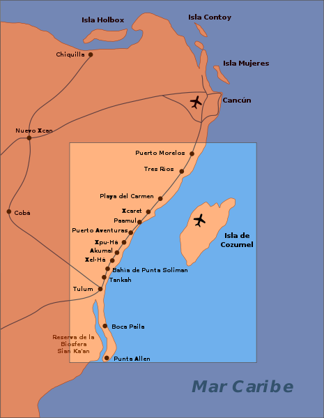
Riviera Maya, also known as the Mayan Riviera, is a tourism district following the coastal Highway 307 which parallels the Caribbean coastline of the Mexican state of Quintana Roo, located on the eastern portion of the Yucatán Peninsula. This district historically started at the city of Playa del Carmen and ended at the village of Tulum, although the towns of Puerto Morelos situated to the north and between Playa del Carmen and Cancun as well as the town of Felipe Carrillo Puerto situated 40 kilometres (25 mi) to the south of Tulum are both currently being promoted as part of the Riviera Maya tourist corridor.
Wikipedia article: http://en.wikipedia.org/wiki/Riviera_Maya
Nearby cities:
Coordinates: 20°21'18"N 87°6'11"W
- Cozumel 28 km
- Cancún 99 km
- Treasure Beach 1017 km
- Runaway Bay 1044 km
- Peninsula Papagayo 1089 km
- Casa de Campo 1916 km
- Uvero Alto 1945 km
- Bávaro 1961 km
- Cap Cana (1st Phase) 1970 km
- Puntacana Resort & Club 1973 km
- Chankanaab National Park 15 km
- Playa Bonita 20 km
- Calica Maritime Terminal 24 km
- Cozumel 25 km
- Hotel Xcaret Mexico 26 km
- Cozumel International Airport 26 km
- Xcaret (Eco park) 26 km
- The Golf Club at Playacar 29 km
- Passion Island 33 km
- Punta Molas 47 km