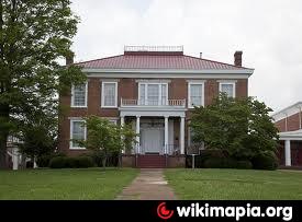
Deshler High School (Tuscumbia, Alabama)
USA /
Alabama /
Tuscumbia /
Tuscumbia, Alabama /
North Commons Street East, 200
World
/ USA
/ Alabama
/ Tuscumbia
World / United States / Alabama
draw only border, high school, school yard
Nearby cities:
Coordinates: 34°44'20"N 87°42'2"W
- Russellville Public Schools 24 km
- Saltillo High School 99 km
- Dickson County High School 153 km
- Arlington High School 189 km
- Center Hill High School 190 km
- Southwind High School 195 km
- Brighton High School 204 km
- Northpoint Christian School 206 km
- South Panola High School 211 km
- Fulton County Schools 243 km
- Seven Mile Island Wildlife Management Area 5.9 km
- Tennessee Valley Authority, Muscle Shoals Campus 6.7 km
- Key Cave National Wildlife Refuge 7.7 km
- Locust Shores 7.9 km
- North West Alabama Regional (MSL/KMSL) 8.7 km
- Underwood-Petersville, Alabama 15 km
- Kendale Gardens 16 km
- Robert Trent Jones Golf Trail - The Shoals 17 km
- Navistar International Corp. 17 km
- River Bend Solar Power Farm 17 km
Seven Mile Island Wildlife Management Area
Tennessee Valley Authority, Muscle Shoals Campus
Key Cave National Wildlife Refuge
Locust Shores
North West Alabama Regional (MSL/KMSL)
Underwood-Petersville, Alabama
Kendale Gardens
Robert Trent Jones Golf Trail - The Shoals
Navistar International Corp.
River Bend Solar Power Farm