Anthorn transmitter station
United Kingdom /
Scotland /
Annan /
World
/ United Kingdom
/ Scotland
/ Annan
World / United Kingdom / Scotland
military, LORAN, VLF transmitter station
The Anthorn Transmitting Station is located near Anthorn, Cumbria and is operated by Babcock International who took over the former contractor VT Communications. It has two transmitters: one VLF and one LF.
The characteristic triangular pattern of roads, clearly visible on the aerial photograph, is a remnant from the World War II military airfield which was operated by the Royal Navy Air Service as HMS Nuthatch.
VLF transmitter
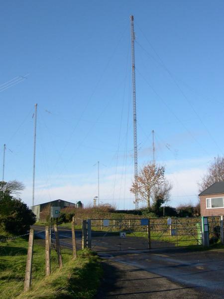
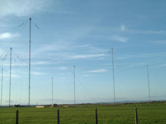
The VLF transmitter is used primarily for transmitting orders to submarines on 19.6 kHz. Its callsign is GBZ.The antenna system consists of 13 masts, each 227 metres (745 ft) tall, which are arranged in two rings around the central mast. The VLF antenna consists of 4 rhombic antennas hung on large insulators on the masts, which are all grounded.
The LF antenna is a T-antenna spun between two masts.
It is a NATO facility, controlled from Northwood Headquarters along with three other VLF transmitters in Norway, Germany and Italy.
LF transmitter: National Physical Laboratory time signal
The National Physical Laboratory (NPL) has installed three atomic clocks at Anthorn and on 27 February 2007 Britain’s national time signal transmissions, retaining their original call sign of MSF, were transferred there on a trial basis, moving formally on 1 April 2007. Monitoring and logging of the clocks and control of the transmissions is by internet link from the NPL offices at Teddington, using comparison with GPS signals at both locations. Signal monitoring is by radio. To ensure accuracy, dynamic adjustment of the aerial according to local conditions (such as wind distortion) is controlled from computers on site. The signals, transmitted at 60 kHz, also provide a national frequency standard. The effective radiated power is 15 kW.
LORAN
The General Lighthouse Authorities for Britain and Ireland have contracted VT Communications to develop eLORAN (enhanced LORAN) radio navigational aid for mariners. The transmitter is at Anthorn, transmitting the Yankee secondary signal on GRI 6731.
tx.mb21.co.uk/gallery/anthorn.php
The characteristic triangular pattern of roads, clearly visible on the aerial photograph, is a remnant from the World War II military airfield which was operated by the Royal Navy Air Service as HMS Nuthatch.
VLF transmitter
The VLF transmitter is used primarily for transmitting orders to submarines on 19.6 kHz. Its callsign is GBZ.The antenna system consists of 13 masts, each 227 metres (745 ft) tall, which are arranged in two rings around the central mast. The VLF antenna consists of 4 rhombic antennas hung on large insulators on the masts, which are all grounded.
The LF antenna is a T-antenna spun between two masts.
It is a NATO facility, controlled from Northwood Headquarters along with three other VLF transmitters in Norway, Germany and Italy.
LF transmitter: National Physical Laboratory time signal
The National Physical Laboratory (NPL) has installed three atomic clocks at Anthorn and on 27 February 2007 Britain’s national time signal transmissions, retaining their original call sign of MSF, were transferred there on a trial basis, moving formally on 1 April 2007. Monitoring and logging of the clocks and control of the transmissions is by internet link from the NPL offices at Teddington, using comparison with GPS signals at both locations. Signal monitoring is by radio. To ensure accuracy, dynamic adjustment of the aerial according to local conditions (such as wind distortion) is controlled from computers on site. The signals, transmitted at 60 kHz, also provide a national frequency standard. The effective radiated power is 15 kW.
LORAN
The General Lighthouse Authorities for Britain and Ireland have contracted VT Communications to develop eLORAN (enhanced LORAN) radio navigational aid for mariners. The transmitter is at Anthorn, transmitting the Yankee secondary signal on GRI 6731.
tx.mb21.co.uk/gallery/anthorn.php
Wikipedia article: http://en.wikipedia.org/wiki/Anthorn_radio_station
Nearby cities:
Coordinates: 54°54'42"N 3°16'43"W
- Olonkinbyen, Weather station, LORAN-C transmitter 1802 km
- LORAN-C Station Fox Harbour, Labrador 3390 km
- LORAN-C Station Cape Race, Newfoundland 3540 km
- LORAN-C Station Nantucket, Massachusetts 4978 km
- Beetle A LF LORAN Radio Station 5869 km
- LORAN-C Station Tok, Alaska 6419 km
- LORAN-C Station Shoal Cove, Alaska 6875 km
- LORAN-C Station George, Washington 7222 km
- United States Coast Guard Sitkinak LORAN A/C Station 7353 km
- USCG LORAN-C Station, Searchlight 8068 km
- Kirkbride Airfeld 5.7 km
- Powfoot Golf Club 8.3 km
- Annan 8.6 km
- Silloth Golf Club 10 km
- Explosives Storage Depot : Eastriggs 10 km
- Waterside 13 km
- Aspatria Solar Farm 15 km
- Allonby 18 km
- Solway Firth 50 km
- Dumfries & Galloway Council 50 km