Bristol Ferry
| ferry terminal
USA /
Rhode Island /
Portsmouth /
Bristol Ferry Road
World
/ USA
/ Rhode Island
/ Portsmouth
World / United States / Rhode Island
ferry terminal
Add category
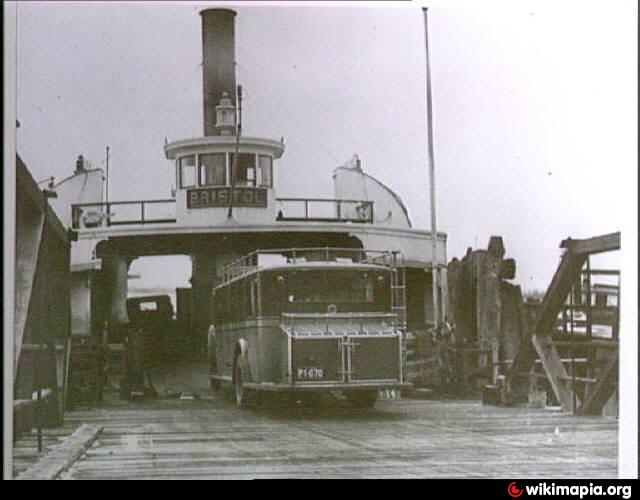
Site of old Bristol Ferry Landing.
[see post on the 2 horsepower ferry that was in service here in 1824-1825 - portsmouthhistorynotes.wordpress.com/2012/04/22/horse-p... ]
[see post on the 2 horsepower ferry that was in service here in 1824-1825 - portsmouthhistorynotes.wordpress.com/2012/04/22/horse-p... ]
Nearby cities:
Coordinates: 41°38'15"N 71°15'12"W
- Lake Champlain Transportation Company - Grand Isle, VT to Plattsburgh, NY 382 km
- Fassett - Lefaivre Ferry 533 km
- Waupoos Island 537 km
- Marine Atlantic - Digby Ferry Terminal 559 km
- Cedar Point, Ontario 801 km
- Caribou Ferry Terminal 826 km
- Wood Islands Ferry Terminal 835 km
- Country Harbour Ferry 866 km
- Marine Atlantic Ferry Terminal 1018 km
- Marine Atlantic Terminal, Port-aux-Basques 1164 km
- Common Fence Point 2.5 km
- The Carnegie Abbey Club 3.4 km
- Portsmouth Abbey School 4.1 km
- Tiverton, Rhode Island 4.8 km
- Nanaquaket Pond 5.3 km
- Nanaquaket Neck 5.3 km
- Raytheon 7.4 km
- Newport County, Rhode Island 8 km
- Bristol County, Rhode Island 8.3 km
- Melville, Rhode Island 10 km