Lares
Puerto Rico /
Ponce /
Lares /
Profesor Enrique A. Laguerre Highway (PR-111)
World
/ Puerto Rico
/ Ponce
/ Lares
World / Puerto Rico
city, village, municipality
Lares is a mountain municipality of Puerto Rico's central-western area located north of Maricao and Yauco; south of Camuy, east of San Sebastián and Las Marias; and west of Hatillo, Utuado and Adjuntas. Lares is spread over 10 wards and Lares Pueblo (Downtown Lares). It is part of the Aguadilla-Isabela-San Sebastián Metropolitan Statistical Area.
A city adorned with Spanish-era style churches and small downtown area stores, Lares is a breezy area that is about 1.5 hours from San Juan by car.
Lares has one major claim to fame: The 1868 uprising that happened there, brought on by pro-independence rebels who wanted Puerto Rico to gain its freedom from Spain. The movement, known thereafter as El Grito de Lares (literally, The Cry of Lares, or Lares Revolt), was soon extinguished, making Lares the site of the shortest-lived republic ever.
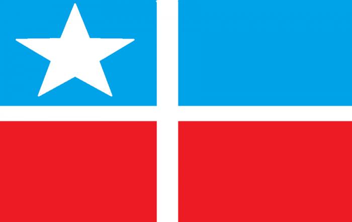
The flag of Lares is now considered by many Puerto Ricans to be the symbol of their independence movement. Initially developed to represent the island's struggle to gain its emancipation from Spain, the flag is now used by those struggling to liberate the island from the United States.
A city adorned with Spanish-era style churches and small downtown area stores, Lares is a breezy area that is about 1.5 hours from San Juan by car.
Lares has one major claim to fame: The 1868 uprising that happened there, brought on by pro-independence rebels who wanted Puerto Rico to gain its freedom from Spain. The movement, known thereafter as El Grito de Lares (literally, The Cry of Lares, or Lares Revolt), was soon extinguished, making Lares the site of the shortest-lived republic ever.
The flag of Lares is now considered by many Puerto Ricans to be the symbol of their independence movement. Initially developed to represent the island's struggle to gain its emancipation from Spain, the flag is now used by those struggling to liberate the island from the United States.
Wikipedia article: https://en.wikipedia.org/wiki/Lares,_Puerto_Rico
Nearby cities:
Coordinates: 18°16'9"N 66°51'54"W
- Utuado 10 km
- Ponce 21 km
- Boa Vista 1831 km
- Oiapoque (municipality) 2261 km
- Calçoene 2398 km
- Amapá 2499 km
- Ferreira Gomes 2565 km
- Cutias 2579 km
- Macapá 2621 km
- Santana 2623 km
- Buenos Aires 2 km
- La Torre 2 km
- Mirasol 3.2 km
- Lares 3.3 km
- Río Prieto 6.4 km
- Callejones 6.5 km
- Santa Isabel 6.7 km
- Ángeles 7.2 km
- Piletas 7.5 km
- Bartolo 7.8 km