Moles de Xert
Spain /
Castelly /
Xert /
A-4 (Autovía del Sur)
World
/ Spain
/ Castelly
/ Xert
World / Spain / Comunidad Valenciana / Castellón / Baix Maestrat
mountain
Add category

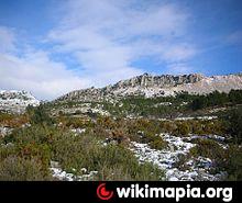
Moles de Xert is a 4.2 km (3 mi) long mountain range in the Baix Maestrat comarca, Valencian Community, Spain. Its highest point is Mola Gran (806 m).
Wikipedia article: http://en.wikipedia.org/wiki/Moles_de_Xert
Nearby cities:
Coordinates: 40°32'37"N 0°9'17"E
- Mount El Montsia 32 km
- Mont Caro (1447m) 34 km
- El Bartolo 52 km
- Serra d'Oltà 209 km
- Natural Park of Peñón de Ifach 212 km
- Sierra de Toix 213 km
- El Toro (Minorca) 341 km
- Carierre alg 487 km
- alg 487 km
- Djbel Lalla Takouba 638 km
- The Chapel of Saint's Saint Isabel 7 km
- Vallivana Sanctuary 8.6 km
- Football court 8.7 km
- Cemetery 8.8 km
- Church 14 km
- The castle of Cervera 14 km
- The Chapel of the Virgin of Avellà 14 km
- Castell de Cabres 16 km
- Reservoir 17 km
- Cemetery 19 km