Fisher Towers Picnic Area & Campround
USA /
Utah /
Castle Valley /
World
/ USA
/ Utah
/ Castle Valley
World / United States / Utah
campground, viewpoint, picnic area
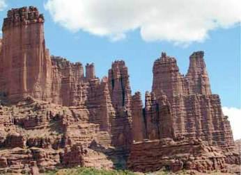
View of the Fisher Towers.
Wikipedia article: http://en.wikipedia.org/wiki/Fisher_Towers
Nearby cities:
Coordinates: 38°43'31"N 109°18'32"W
- James M Robb-Colorado River State Park 68 km
- Squaw Flat Campground 77 km
- Spanish Bottom 83 km
- Morefield Campground 176 km
- Crescent Regional Camps 196 km
- Soldier Creek Recreation Area 219 km
- Currant Creek Reservoir 236 km
- Blackhawk Campground 239 km
- San Juan County McGee Park 249 km
- Deer Creek Reservoir 273 km
- Fisher Towers 0.9 km
- Richardson amphitheater 3.8 km
- Fisher Mesa 8.2 km
- Dome Plateau 8.3 km
- Adobe Mesa 11 km
- Beaver Creek Canyon 18 km
- Off-Road Race Track 24 km
- La Sal Mountains or La Sal Range 28 km
- Gateway Canyons Resort 29 km
- Sinbad Valley 36 km