Inner Approaches to New York Harbor
USA /
New Jersey /
Highlands /
World
/ USA
/ New Jersey
/ Highlands
World / United States / New Jersey
water, strait / channel / passage / narrows, invisible, do not draw title
Outer entrance to the Ambrose Channel
Ambrose Channel is the main shipping channel in and out of the Port of New York and New Jersey. The channel is considered to be part of Lower New York Bay and is located several miles off the coasts of Sandy Hook in New Jersey and Breezy Point, Queens in New York. Ambrose Channel terminates at Ambrose Anchorage, just south of the Verrazano Narrows Bridge, the gateway to New York Harbor.
All mercantile shipping bound to and from New York Harbor uses the channel which is marked and dredged.
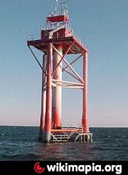
The entrance to the channel was marked by Ambrose Light which doubled as a staging area for pilot boats, most notably the Sandy Hook Pilots. Prior to the construction of the light tower in 1967 (see photo above) the channel was marked by the Ambrose Lightship, one of a class of lightships operated and maintained by the United States Coast Guard for the express purpose of marking main shipping channels for major ports. After several collisions, the light tower was redesigned and relocated in 1999, and finally decommissioned and removed in 2008.
www.sandyhookpilots.com/ops.asp
Ambrose Channel is the main shipping channel in and out of the Port of New York and New Jersey. The channel is considered to be part of Lower New York Bay and is located several miles off the coasts of Sandy Hook in New Jersey and Breezy Point, Queens in New York. Ambrose Channel terminates at Ambrose Anchorage, just south of the Verrazano Narrows Bridge, the gateway to New York Harbor.
All mercantile shipping bound to and from New York Harbor uses the channel which is marked and dredged.
The entrance to the channel was marked by Ambrose Light which doubled as a staging area for pilot boats, most notably the Sandy Hook Pilots. Prior to the construction of the light tower in 1967 (see photo above) the channel was marked by the Ambrose Lightship, one of a class of lightships operated and maintained by the United States Coast Guard for the express purpose of marking main shipping channels for major ports. After several collisions, the light tower was redesigned and relocated in 1999, and finally decommissioned and removed in 2008.
www.sandyhookpilots.com/ops.asp
Wikipedia article: http://en.wikipedia.org/wiki/Ambrose_Channel
Nearby cities:
Coordinates: 40°29'49"N 73°54'41"W
- (West) Rockaway Inlet 10 km
- Jamaica Bay Wildlife Refuge 17 km
- "The Narrows" 21 km
- Lower New York Bay 23 km
- Upper Bay 27 km
- Upper New York Bay 29 km
- Raritan Bay 31 km
- Newark Bay 33 km
- riverdale canal 48 km
- Harlem River 51 km
- Wreck of USS Turner (DD-648) 3.6 km
- Queens 17 km
- Monmouth County, New Jersey 36 km